Objectives of the service
Sustainable agricultural production is becoming increasingly important in the commodity market, both for consumers and industry players. To promote environmentally and socially sustainable food production, certification systems have been introduced by organisations such as Fairtrade, UTZ and Rainforest Alliance on the "first mile" of the supply chain. These certification standards provide guidelines to maintain the ecological functions of the production system, minimise negative environmental impacts, guarantee the quality of the product and ensure socially responsible production. Producers are audited by independent certification bodies (CBs) to ensure that these standards are met. However, fraud is a major problem, products are mislabelled and not produced according to sustainability standards and CBs do not have enough means to verify the auditing process carried out by their local staff. Certification bodies need objective information to assure that farmers claiming to produce sustainably really comply with sustainability principles. The envisaged service provides such information by assessing the farming practice derived from objective satellite-based earth observation data.
Users and their needs
The EO4CS project targets all relevant stakeholders supporting the sustainable production of cocoa including certification organisations such as Rainforest Alliance, Fairtrade and Organic, certification bodies, farmers and cooperatives and civil society organisations. Two certification bodies and one civil society organisation are actively involved in the project. The certification bodies operate globally and audit the cocoa production in the main cultivation basins in Latin America, West Africa and Asia. Following user needs have been identified during the project:
Certification bodies:
-
The local management of CB’s need objective information on the ecological quality of cocoa landscapes for verifying the certification process of their local auditors.
-
Local auditors of CB’s need such information for accelerating the auditing process, getting a comprehensive picture of the farming practice also in remotely situated areas and for decision support.
Certification organisations:
-
They need objective information to assure the certification decision by their authorized certification body.
Producers and civil society organisations:
-
They need information for judging to what degree currently uncertified farmers already fulfil the requirements of the voluntary sustainability standards and pinpointing areas with high conservation value.
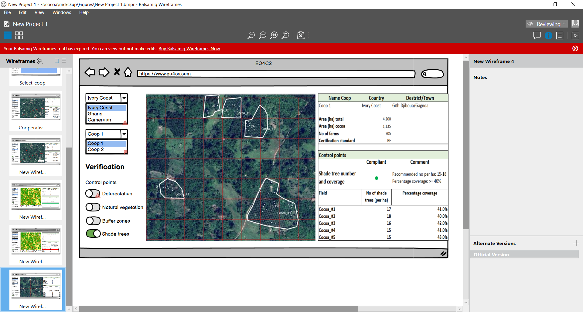
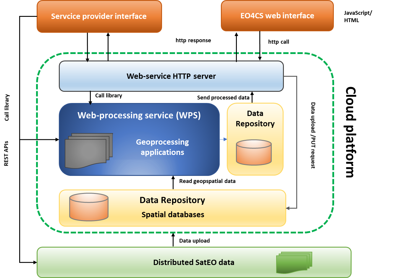
Service/ system concept
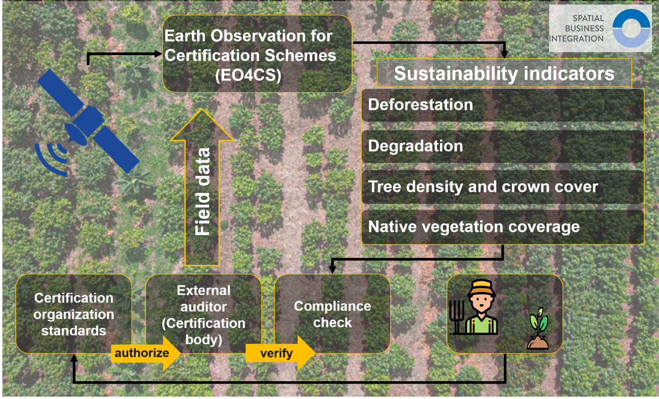
The EO4CS service is a solution that combines earth observation and geographical information data into a cloud-based processing environment and provides value-added information products to the end-users. The system integrates thereby all required input data including satellite imagery, field boundaries of cocoa plantations, boundaries of protected and restricted areas and related buffer zones and computes the information products through an automated processing chain. The envisaged service focuses on the environmental pillars set in the voluntary sustainability standards and provide e.g., the following information:
-
Cocoa production occurring in or within a certain radius of a protected area
-
No deforestation or degradation of primary forest occurs or has occurred
-
Buffer zones are kept along with water bodies
-
Farms have enough native vegetation coverage across the farm
-
Farms have a sufficient number and crown coverage of shade trees on their fields
With that objective information by hand, local auditors are enabled to (a) assess the environmental control points of the sustainability standard remotely, reducing thereby the efforts for on-site inspections and mitigating associated risks and (b) can comprehensively monitor the entire production area under investigation. Secondly, certification bodies and certification organisations would have means and objective measures to supervise and verify the auditing decision of local auditors.
Space Added Value
The proposed service utilises satellite-based earth observation (EO) data, including optical and, if necessary, Synthetic Aperture Radar (SAR), in cases imagery is contaminated with clouds. For detecting deforestation and forest degradation at broader scales, moderate-resolution imagery captured, e.g., by Modis, Landsat and Sentinel-2, can be employed. Identifying single tree removals requires high and very high-resolution imagery as provided e.g., by PlanetScope, WorldView or SPOT. Also, counting shade trees and calculating the crown coverage of shade trees within cocoa plantations can be only achieved with very high spatial resolution.
Currently, certification bodies employ true-colour imagery from unmanned aerial vehicles or satellites (e.g., Google Earth imagery) and visually inspect if the farming practice complies with the sustainability principles. They verify for example if cocoa cultivation occurs in banned areas or count shade trees. However, this practice is often error-prone since cocoa trees, particularly elder ones, can be easily confused with native vegetation.
Satellite imagery in combination with deep learning object detection and classification methods provide reliable information. They also offer historical time series for monitoring sustainability indicators over defined periods.
Current Status
In this study, the user needs of two certification bodies operating in the major cocoa-producing regions of West Africa and Latin America were comprehensively surveyed to make certification practices more transparent, effective and reliable. Based on these findings, four services were defined that use SatEO data in combination with appropriate processing algorithms to remotely verify the key ecological control points of certification. These services include automatic identification of deforestation, historical and current land use to assess biodiversity and conservation of ecologically sensitive ecosystems, and the presence of ecologically valuable native shade trees in cocoa plantations.
The required SatEO data and other input data were identified, suitable system components for sustainable service provision in the cloud environment were elaborated, and a pricing model was developed. The next step is to implement the service components in an operational environment, to gain pilot customers and funding resources to eventually bring the service operationally to market.