
Objectives of the service
Mobility touches almost every aspect of our lives and its restrictions can feel like a loss of freedom. People with reduced mobility are more affected by poor or lacking pedestrian and transport infrastructure, such as bad route conditions or insufficient road crossings.
Current mapping services give only partial accessibility information and focus on discrete locations such as building interiors, train stations or touristic sites.
However, routes that connect these points of interest do not take mobility into account when providing directions or travel time. This ‘last mile’ support has a huge effect on people’s ability to explore surroundings or reach specific places and is so far unaccounted for.
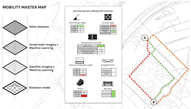
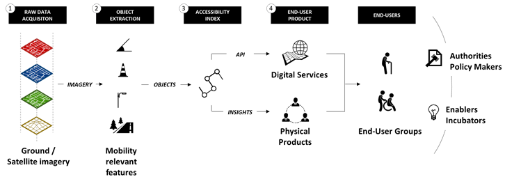
High resolution imagery, including satellite, can be used to identify route conditions and specific features affecting accessibility. Combining space-derived data with street level and crowd-sourced information as well as other relevant datasets we build a personalised accessibility index called “Mobility Master Map”.
Users and their needs
At any one time, 40% of us experience some restriction of our mobility.
Whether that is
- Temporary, if you are injured and need crutches
- Permanent, if you are an elderly individual or a wheelchair user
- Or simply if you are in a situation that restricts your movements, with a child in a push chair
All people with reduced mobility are more affected by poor or lacking pedestrian and transport infrastructure, bad route conditions or insufficient road crossings.
People want to choose routes according to their own needs.
Whether this is a route that:
- Avoids roadworks
- Is close to public transport links or rest stops,
- Avoids stairs,
- Or takes the flattest path, even if its longer.
In short, Travel and Planning is not one size fits all.
Globally.
Service/ system concept
1) We combine street level and satellite imagery, digital elevation models and crowd sourced data.
2) We then extract a range of features relevant to accessibility, for instance stairs, slopes or benches.
3) Finally we attribute a weight to each feature according to a user profile, effectively creating a ‘mobility map’
Space Added Value
GNSS and Satellite Imagery are used, allowing the deployment of the solution at scale, and with a level of calibration which would not achievable were one to use only street-level imagery (e.g. Google Streetview).
Current Status
User needs have been captured by running user research workshops in partnership with Visit Greenwich and Digital Greenwich (https://www.digitalgreenwich.com/), allowing initial assumptions to be validated. These have shaped technology requirements and steered the development of a proof of concept.
Follow-on activities will focus on engaging with partners aiming to develop a prototype demonstrator in an operational environment.
Prime Contractor(s)