Objectives of the service
According to the principal national strategic document in respect of climate change “one of the most important adaptation measures is developing a system of integrated agro-meteorological monitoring and alerts. Its output must be directed to the operational advisory in agriculture. Despite a number of proposals this key issue has not been given sufficient attention and support”.
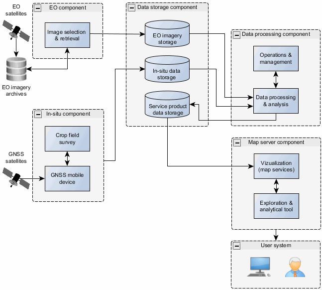
DROMAS Agricultural Crop Monitoring service will deliver an innovative tool to provide periodically updated information on crop types and crop cover to national administration. The service products are represented by crop maps with associated metadata layer of anomaly detection allowing monitoring of agro-environmental degradation and agricultural crop damages on the agricultural parcel level. The service is provided on-line via web mapping services.
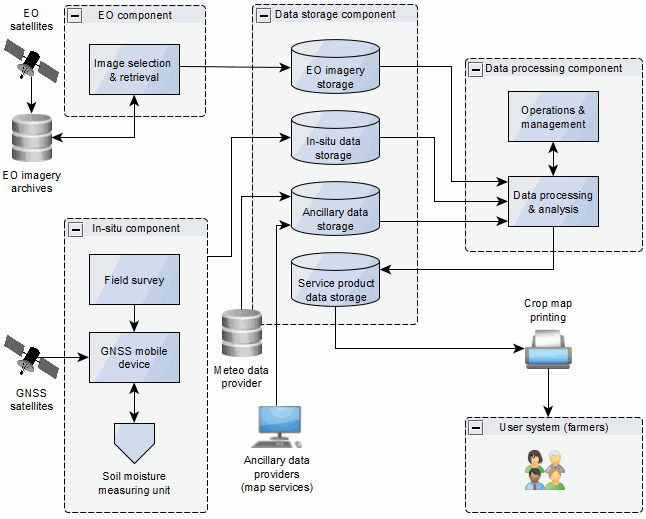
DROMAS Farming Management Service will provide monitoring of agricultural crops at parcel level to support farm decision making. The service delivers field-level historical time-series analysis of crop spatial variability to assess farming management practice and provides current crop growth monitoring to enhance the practice. The field crop historical analysis is interpreted together with auxiliary data (e.g. soil map, topographic map, temperature and precipitation data). Current year monitoring can be supplemented by the soil moisture measurements to interpret drought events. The service products are provided in the form of printed crop maps.
Users and their needs
The Czech Ministry of Agriculture (MoA), State Agricultural Intervention Fund (SAIF) and agricultural producers (Farmers) represent three main end users of the proposed monitoring services. They stand on opposite sides of the financial flows resulting from damage caused by natural disasters and agro-environmental degradation but they have a common interest in minimizing the threat to agricultural production in the country.
User needs:
- Timely information on which farms and which parcels are affected by the natural disaster
- Up-to-date information on know which crops are grown on individual parcels and if there are any anomalies in the crop growth.
- Information on which agricultural parcels are characterized by high spatial and temporal crop variability within the parcel repeated over a multi-year period.
Target users are from the Czech Republic.
Service/ system concept
The proposed system consists of separated components that represent technical solution to fulfill individual service requirements identified in the feasibility study:
- Earth Observation component - selection and provision of suitable satellite imagery
- In-situ component – acquisition and provision of field survey crop information and soil moisture data
- Data storage component – data storage and data management
- Data processing component – data processing and analysis
- Map server component – service products provision to the user
The schematization in the figures below provides technical viewpoint of the intended service.


Space Added Value
Earth Observation and Satellite Navigation represent two space assets that enable implementation of the service compliant with identified user requirements.
Earth Observation is the only technology that can provide feasible solution for historical and operational crop monitoring in needed spatial and temporal resolution.
Satellite Navigation is the technology providing the solution for operational targeted in-situ data collection focused on support of satellite image data analysis and for positioning of in-situ sensors for soil moisture measurement.
Current Status
DROMAS Feasibility study concluded in May 2015. The Feasibility study assessed and proved the concept of two agricultural services focusing at operational monitoring of agricultural vegetation to serve decision makers on national level and to provide historical and current year crop analysis to support farm management at agricultural parcel level. Due to the positive feedback received by the users and the confirmed viability of the service, the team is in the process of preparing an ARTES 20 demonstration project.


