Objectives of the service
The FS project objectives are to find out the user needs, constraints and required context through close collaboration with a selected number of Dutch water utilities during the study. The objectives may be summarized as per the items below:
- The services have to be compatible with existing data management systems. Within the FS this compatibility has been proved.
- (Near) remote sensing of ecological water quality parameters requires a mind shift from lab based monitoring towards a new way of monitoring. The FS objective is to determine the hurdles to achieve this shift. It has been concluded that a scientifically sound basis for using the technology is preferred, e.g. by open source access to algorithms applied, certifying agents, etc.
- An important objective for the users is to secure the economic feasbility: the overall costs for monitoring should not be increased, as the utilities budgets are under continuous pressure.
- The accuracy of the monitoring results should be unquestioned and is a show-stopping objective. The present results achieved in the feasibility study are considered to be promising.
- A FS objective is to determine the requirements and availabity of future satellite images of high resolution. It has become clear that this is crucial for future data generating. The field monitoring (WISP-3, ECOWATCH) are for ground truthing only.
The project aims at setting up services for relevant water quality monitoring based upon remote sensing for fresh water bodies, with particular interest in the occurrence of cyanobacteria. The services should allow the water quality management to make objective decisions for improvement, mitigating actions and remediating options. It should result in a cheaper way of water quality monitoring, while generating more accurate output.
The collected data will be used to optimize the parameters of a decision support model for water quality managers that allow assessment of the likelihood of cyanobacteria blooms in the future and suggest prevention/remediation options.
From the results of the FS it is our objective to develop a reliable method and decision support model for detecting cyanobacteria presence in fresh surface water bodies using optical readings. For this it is required to grow the dataset using satellites, and hand held monitors. This database, in combination with the knowledge of conversion algorithms, becomes the major asset in offering commercial services for predicting cyanobacteria growth and bloom formation. The data will be fed into existing data management systems and can then be used as part of the decision support management system.
Users and their needs
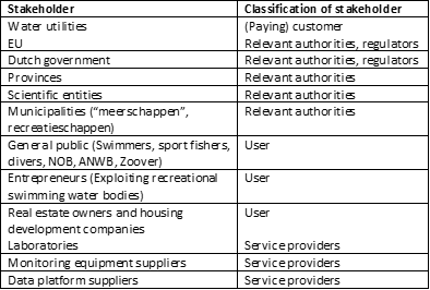
The prime target users are water utilities, responsible for surface water management, which includes both water quantity and quality. The water utilities will be the prime (paying) customers, consuming our services.
Various other stakeholders are also relevant, but for different reasons. Reference is made to table 1.
Service/ system concept
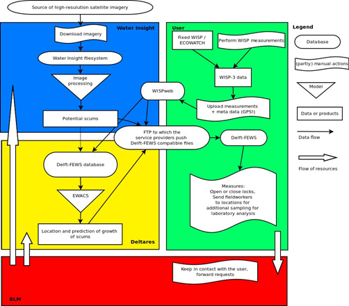
The most appropriate services to the users, derived from the FS, have been identified as being a mixture of water quality monitoring, data handling, modelling and presenting relevant output to the users. This workflow has been illustrated in a flow chart (figure 2)
In the high level block diagram (or flow chart) the water quality monitoring sources, which are part of CyMonS, are highlighted, including the workflow to convert the raw data into reliable output, which can consecutively be used by the client in FEWS and EWACS.
Our services are focusing upon generating reliable water quality datasets from various sources: satellite images, WISP-3 and ECOwatch (a fixed position field monitor).
In order to provide our clients with appropriate products that both suits their needs as well as their budget for water quality monitoring we have developed in the feasibility phase 3 packages, ranging from the relatively simple “Basis Package” to the full service “Gold Package” as well as the intermediate “Silver Package”. The costs consist of two categories: initial set up and installation costs, and the operational annually recurring costs.
Space Added Value
The following space assets are crucial for CyMonS:
- Earth Observation, using appropriate satellites (in terms of spatial, temporal and spectral characteristics)
- GNSS positioning of the field monitors and fixed mounted monitors.
Current Status
The project started in February 2014 and was concluded in January 2015. The most significant achievements of the project have been summarized below:
- Large datasets have been generated with the use of the hand held field monitors and satellite images; these datasets have been successfully integrated into the current data management system of water utility Noorderzijlvest (FEWS)
- The detailed data set has been successfully implemented in the forecasting model EWACS, Early Warning of Cyanobacteria Scums) in order to predict cyanobacteria scums in the lake Paterswoldsemeer.
- The rough forecasting procedure for the Rijnland lakes proved to be inadequate for predicting accurately any scum formation. However the user still appreciated the predictions.
- More detailed and local information regarding wind patterns is required to compensate for local circumstances and to improve the predicting power of the forecasting tool.
- The present forecasting model requires considerable runtimes. This issue should be integrated into a more sufficient calculation methodology during the demo phase.
- Separate from the hand held WISP-3 monitor a need for fixed position field monitoring is expressed.
- It has become clear that a further implementation of the services is possible by a combination of satellite image processing and field data processing. It would be appreciated if the appropriate satellites (in terms of spatial and temporal characteristics) will be improved in the future.
- Generally the users have indicated the present results are a good basis for executing a demonstration phase. Both present water utilities have indicated they would like to participate in the demonstration.
For the project to be implemented smoothly within the existing infrastructure of the participating water utilities, it is crucial to create good datasets which can be used by both the water utility to visualize in FEWS and Deltares to run EWACS. Within the projected demonstration phase the work package related to the monitoring program is therefore essential.
The demonstration phase requires an active involvement of the users. Therefore some frontrunner water utilities have been selected to participate in the pilot. The pilot will run through two seasons (2015 and 2016) and requires extensive field monitoring at the various lakes to feed the system. Furthermore all relevant satellite images will be collected and interpreted.
The following activities are scheduled for the demonstration pilot:
- WISP-3 monitoring and data processing, including automatic scum flagging.
- Developments towards inclusion of GNSS in the WISP-3 will be continued.
- Satellite data processing.
- Pre-operationalize the EWACS hindcast model run
- Data-handling of forecast data that feed the EWACS forecast model run
- Pre-processing activities, including validation of WISPweb data
- Post-processing activities, e.g. composing maps with presence of scum layers
- Setup of new modeling framework for additional areas
- Improvements of the data-handling workflows
- Graphical presentation of forecasting results (EWACS) of scum layers
- Operationalize the modeling framework
Prime Contractor(s)
Subcontractor(s)
