
Objectives of the service
Vulnerability and exposure data currently used by insurance and re-insurance companies lack in terms of resolution and accuracy when risk models are used to determine fair premium levels.
The ideal “exposure information on urban areas” would include characterizing each building in terms risk-related features, such as number of stories, occupancy, year built, area, construction type, number and size of windows, and countless other features. Insurance companies are hungry for such data, that would allow them increase their competitiveness, in a framework where large-scale statistics are still the go-to solution, while at the same time retaining a balanced level of financial risk.
CountFloors will provide better exposure data to the (re)insurance companies, and -at the same time- to the covered municipalities, which get the generated data for free. Insurers are available to pay for such exposure data because it narrows significantly the uncertainty on risk estimates, thus allowing to offer more competitive insurance rates. Other markets such as real estate are being considered.
Users and their needs
There exists a clear gap in detailed exposure information with respect to hazard information when risk modelling is concerned. The pool of identified users currently handles the lack of exposure information in different ways.
Re/Insurance companies often ground their analysis on general statistics, and/or partial or incomplete data. Broad statistics are somehow dangerous because their reliability is undefined for local cases; most statistic parameters are defined and collected in different ways country by country, and sometimes differing definitions are found even within the same country. In case of an incomplete datasets, risk modellers have to make assumptions on the study area in order to fill the data gap. Accordingly, catastrophe modelling software packages will produce reliable results only in those areas where data is available, but potentially (or factually) inaccurate results elsewhere. These uncertainties may heavily affect potential compensation costs, and need to be statistically offset by an increase in insurance fees. In other words, uncertainty means loss of financial competitiveness.
Municipalities are not necessarily proactively seeking to increase the level of detail of exposure information in their local risk analysis, as they may not be mandated to do so or may lack the necessary financial resources. Receiving exposure data for free surely does not harm but it may also result in improved risk analysis and better decision making to the benefit of citizens.
We are currently focussing on Europe and the U.S. but plan to extend the service to South America and South-East Asia soon.
Service/ system concept
CountFloors will provide per-building risk exposure-related data, with a global geographical scope. For each building, different features will be retrieved from street-level pictures, e.g. number of floors, occupancy, number of windows, etc...
Copernicus Sentinel-2 and Sentinel-3 multitemporal optical spaceborne data will be used to map the boundaries of urban areas. Once identified, the workflow depicted in the figure below will be applied.
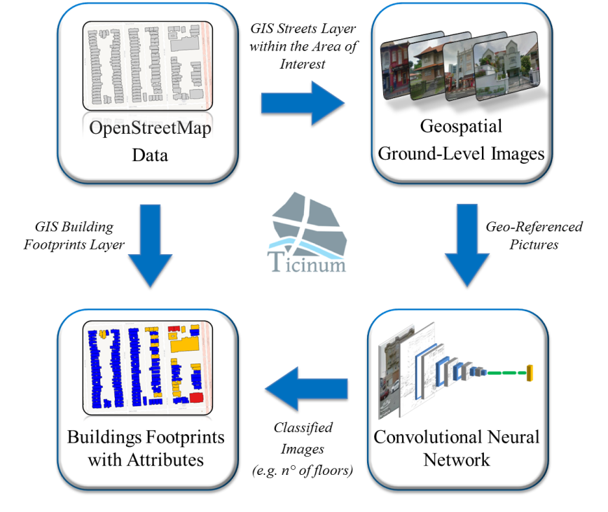
The system is composed of three main blocks:
• a block for automatized retrieval of in-situ georeferenced photos in the area of interest;
• a block operating trained, suitably shaped convolutional neural networks, in charge of extracting risk-relevant features for each imaged building;
• a block with a geospatial platform handling the GIS layer of the urban buildings and an algorithm assigning the produced exposure label to the relevant building footprint.
Space Added Value
GNSS systems underpin geolocation of street pictures. Spaceborne Earth observation data, specifically Sentinel data are used to build precise, up-to-date maps of urbanized areas; third-party mission data, specifically very-high-spatial-resolution optical data, are used to extract building footprints where these are not available from open databases such as OpenStreetMap.org.
Current Status
The project was concluded in October 2018.
Further development of the software platform supporting CountFloors is in progress, with the current version being tested and assessed for various test sites in Europe and beyond. After completing the first stage of CountFloors development, a complete test case has been carried out on a region in the Netherlands. Results were produced for a stock in excess of 140,000 buildings covering almost an entire Dutch province, Validation done together with the stakeholders has confirmed the high quality and accuracy of the results delivered.
On the business side, various regional markets are being analysed in order to understand the best strategy for data procurement and service offering.