Objectives of the service
COHABIT innovates: by integrating a multiple “animal presence / habitat” data collection approach (environmental big data, animals tracking data using transmitters, visitors and rangers observations of direct and indirect animals presence; by using image recognition (for processing animal sightings, sounds and indices); by using data analytics (from multiple sources); by generating in real-time geo-fenced cohabitation maps (for wilderness visitors and nearby farmers); and by using space communication (for transferring tracking info and visitors / rangers observations and for pushing back generated presence maps).
COHABIT not only secures the safe and environmental friendly coexistence between big carnivore / omnivore animals and humans in wilderness areas but also fosters the interests of all involved actors, be it Wilderness Organisations and Parks for wildlife conservation, Visitors for safe wandering natural parks and Farmers for optimal protection of their livestock and crops.
Users and their needs
The COHABIT service offer addresses two complementary actors, namely the Wilderness Organisation / Wilderness Parks and the Visitors to wilderness areas as follows:
Wilderness Organisations service offer
- Means to edit and insert fauna habitat GIS data into COHABIT
- Means to insert and edit wildlife protection awareness info for visitors into COHABIT
- Means to network with wilderness parks for wildlife preservation under COHABIT
Wilderness Parks service offer
- Means to edit and insert fauna habitat GIS data into COHABIT
- Means to protect big carnivores / omnivores from human presence
- Means to collect animals’ presence observations and indices from visitors
- Means to receive, on a periodic basis, field transmitted sampled animal movements
- Means to generate geo-fenced presence map of big carnivores / omnivores
- Means to protect visitors from dangerous encounters with big carnivores / omnivores
Visitors & Farmers service offer
- Accessing environmental awareness info about big carnivores / omnivores
- Accessing safety info about big carnivore / omnivore animals’ encounters
- Receiving in real-time geo-fenced maps of big carnivore / omnivore animals’ presence
- Having the visitors’ wilderness itinerary automatically adapted to the geo-fenced animals’ presence to avoid dangerous encounters
- Having the farmers’ crops and livestock better protected through risk levels warning and safeguard instructions
- Being able to identify and report visual observations of big carnivores / omnivores
- Being able to identify and report presence indices of big carnivores / omnivores
COHABIT targets first wilderness areas in Europe and Africa and will expand later in the Americas and Asia. Countries such as Germany, Sweden, Czech Republic, Slovakia, Austria, Italia, Portugal, Romania, Ukraine in Europe and South Africa, Namibia, Botswana, Zimbabwe, Mozambique in Africa will be initially targeted.
Service/ system concept
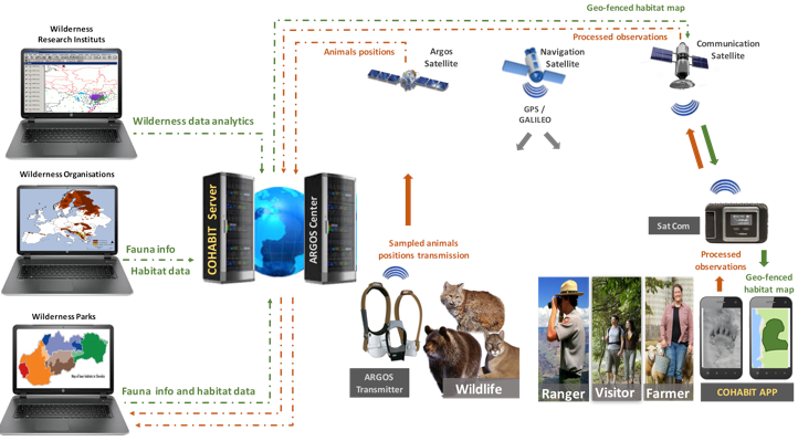
The COHABIT Platform is composed of two main components: I. COHABIT Server to which all the actors connect (Customers: Visitors / Wanderers / Farmers; Environmental Parties: Wilderness Organisations and Parks; Third Parties: Animals Tracking Providers, Satellite communication providers); II. COHABIT Mobile APP enabling Visitors to identify animals’ presence, to report their observations, to receive up-to-date geo-fenced presence maps and to have their wilderness itinerary adapted accordingly, as well as for Farmers to receive in real-time alerts big animals presence reports with risk levels warnings combined with instructions to protect their livestock and crops.
The COHABIT environment and associated elements is illustrated below:
Space Added Value
COHABIT will principally make use of 2 types of space assets as follows:
- Satellite Navigation (GNSS) used for the geo-localisation of the following assets
Observations and reporting of animal sightings, sounds and indices
“Sampled animals” movements tracking
Generation of geo-fenced wildlife protection & visitors’ safety maps
Generation of tailored and real-time adaptive wandering itineraries
Enforcement of geo-fenced wildlife protection & visitors’ safety
Geo-localisation of visitors in wilderness areas
- Satellite Communication (SATCOM) used for the following communication
Sending processed visitors / rangers observations (animal sightings, sounds and indices) from the wilderness where no cell coverage is available
Sending “sampled animals” movement tracking using ARGOS satellites
Receiving geo-fenced wildlife protection & visitor safety map coordinates
Earth observation is only used indirectly by the animals’ habitat sources available to the parks.
Current Status
The COHABIT initial phase of a feasibility study has been achieved and finalised. The study has shown that COHABIT is conceptually, technically and commercially feasible, that it responds to the needs expressed by the participating actors.
The study has been carried out in close collaboration with the European Wilderness Society (EWS) and associated Parks and with the Luxembourg Institute of Science and Technology (LIST). It has enabled the collection of the COHABIT requirements and has highlighted the need to enhance the visitors’ safety in wilderness areas by limiting the probability of dangerous encounters with big wild animals, the need to have visitors become conservation agents by reporting their observations of big animals sightings, traces, indices and sounds, and the opportunity to help famers near or in wilderness areas to better protect their livestock and crops from large wild animals trespassing into their properties.
The COHABIT freemium business model, will enable a gradual familiarisation with the COHABIT APP by the visitors and farmers, thus eliminating any initial uptake barrier and securing over the medium term the needed revenues and commercial viability.
Prime Contractor(s)