Objectives of the service
Due to the increasing demand of electrical power supply especially for the fast-growing economies in the new developing countries, coal mining is still one of the main energy sources.
Currently, the coal mining and trading companies rely on ground observations, long-term trend analysis and shipping logs from the port authorities to make an estimation about the coal movement but that is very complicated, imprecise, time consuming and expensive. On the other hand, the harbors are very varied in their business size, quality & quantity capacity, and the data accessibility.
ATMM intends to enhance the transparency about the local and global coal flows, therefore the service. will show the logistic activities and coal volumetric changes in coal harbor areas uising satellite-derived observations. The service will be provided for each individual harbor, based on time interval delivery and service duration..
Users and their needs
The primary end-users and customers of the proposed services will be the international coal mining companies who are interested to have quick and global analysis of the total coal production, stock and its logistic.
Spatial Business Integration GmbH (SBI) defined and classified the customers to five main categories:
- Mining & logistic companies.
- Power supply companies.
- Database & legal and regulatory consulting companies.
- Investment companies.
- Vessel tracking system companies.
The needs of customers vary according to their main business. Mining companies, for example, need to check the extracted amount of coal and compare it with exported volumes, which can be provided by SBI. Meanwhile, the logistic companies are mainly interested in monitoring the work efficacy in each harbor e.g. which crane is active and the volumes of mobilized dry coal ending with the number of the official – nonofficial vessels in the port.
The benefit of ATMM services will be basically useful to the administration and logistic departments of the power supply, database, legal and investment companies of the USA, Australia, Asia and the EU.
The most challenging item can be the random and nonsystematic shapes of the coal stockpiles which will impact the final estimates of the absolute volume.
Service/ system concept
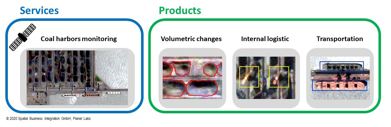
Figure 1: Service and product concept
As a preliminary description the services are:
- Coal mining monitoring within an appropriate time interval. This service will be delivered in multiple formats on a weekly / monthly basis for each of the test sites selected.
- Activity insights of the coal harbors (logistic and volumetric).
- Monitoring coal transporting vessels.
- Defining the stability conditions of the harbors in the term surface subsidence.
The activity overview, activity insights and coal stockpile changes will be delivered as the following products:
- Volumetric changes over time.
- Coal stockpile classification.
- Number and the size of the vessels.
- Active and not active loaders and cranes.
The service design is based on: 1st, Input data and pre-processing. 2nd, post processing, change detection and volumes algorithms. 3rd, results evaluation. 4th, service and products and delivery.
The main aim of building a suitable web application is to deliver the listed products directly to the customers while keeping communication and providing services as simple and comprehensive as possible.
The delivery model will be based on a flat rate or on a weekly basis and the output delivery will be via online portal/interface/documentations according to the customers’ needs.
Space Added Value
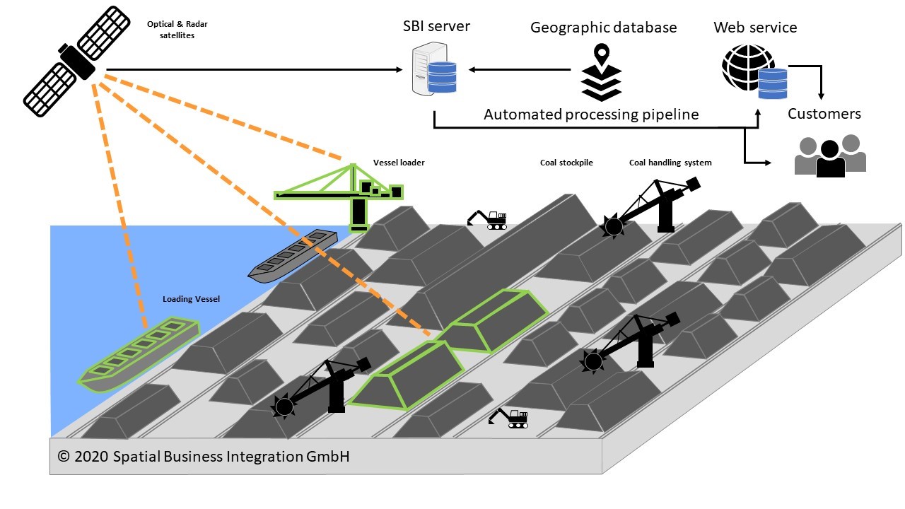
Figure 2: The process flow for coal stockpiles, logistic and the delivery scenarios.
Automated daily access to the optical and radar products of Planet Lab and Copernicus enable the system to detect the geographic location of each stockpile and other logistic equipment’s. The total area and the volumetric analyses will be used to provide the total volumetric capacity map of the selected harbor. Weather data and the adjusted area of interest will be important to keep the best accuracy.
The used satellite data enable the coverage of many areas at the same time, which will be important to fulfill the intention of covering the global coal ports.
Within the ATMM project, the following space assets are used:
- Geographical database and maps for the selection of the area of interest (harbor) and monitoring during pre-deployment.
- Monitoring harbor activities
- Very high spatial and temporal resolution images to define each insight activity.
- Characterize the volume of coal stockpile using mono mode satellite imagery.
- Mthods to turn data from worldwide acquisitions into information products and services on appropriate scales and accuracies
The main intention is to ensure systematic and routine operational activities with a high level of automation and pre-defined operations to the maximum extent possible on a global scale.
Current Status
The study was completed in April 2020.
An automated algorithm has been applied on optical and radar images to automatically detect the absolute volume and changes in stockpiles located in the harbour. The preliminary results have been shown to a few events which triggered the attention of several stakeholders and potential customers.
The promising findings have led the Prime to the preparation of a follow-up Demonstration Project, planned to kick-off in Fall 2020.