
Objectives of the service
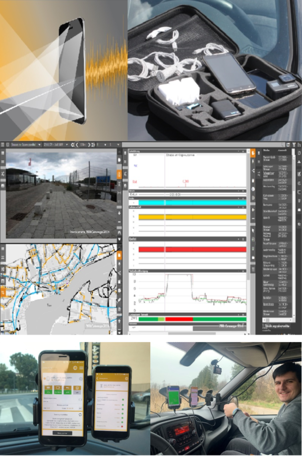
Road administrations need the network-wide evaluation of road condition (evenness, cracks, potholes, etc.) to plan maintenance. However, the collection of such data is cumbersome. It requires costly tenders as well as the use of specialized vehicles and specialized, time-consuming. Consequently, only primary network operators conduct state-of-the-art condition monitoring. It is prohibitively expensive for local road administrators. The ASPEN system fills this gap by allowing for pavement condition assessment using smartphones mounted in a vehicle. A single ride over the whole network suffices to generate online maps and profiles showing road roughness. It is also possible to diagnose individual sections to monitor its degradation, e.g., before and after exposure to heavy traffic related to tree logging.
Our new solution also enables easy measurements of the pavement parameters on sidewalks and bicycle paths by mounting smartphones on e-scooters or bikes.
Users and their needs
With a new, tailored solution, local road authorities can establish pavement management programs at affordable prices. Besides cost-saving advantage, ASPEN system addresses the following needs:
- • Collection of objective road condition data for the whole network
- • Precise attribution of the data to individual road sections
- • Provision of results online using maps, profiles, data tables and video recordings
- • Easy collection and updating of data in-house, for instance “by the way” of rides done for other purposes
Objective road condition data enables efficient spending of maintenance funds and hence facilitates the long-term durability of roads. It is of utmost importance since road networks are among the most valuable infrastructure assets the society has, and so, allowing for their premature wear results in huge, unnecessary costs. Apart from that, the ASPEN system provides also direct information about ride comfort.
Additionally, the ASPEN app is capable of video-recording the ride. After anonymization it is presented online in a “street view” mode. The information about every road section and its surrounding is useful for many purposes such as operational planning, evidencing the road furniture or settling claims concerning, e.g., driveways.
Service/ system concept
Driving an uneven road with multiple surface distresses causes vibrations. Smartphones mounted in a vehicle „tremble like an aspen leaf”. The ASPEN app records these vibrations and couples them with satellite navigation. We use mechanical modelling of vehicle suspension and machine learning techniques to evaluate road evenness through the International Roughness Index (IRI). Our approach is documented in a scientific article in IEEE Intelligent Transportation Systems Magazine available at https://dx.doi.org/10.1109/MITS.2021.3049382. To boost reliability and accuracy of the system we use up to 5 smartphones as vibration sensors in a single ride of the test vehicle.
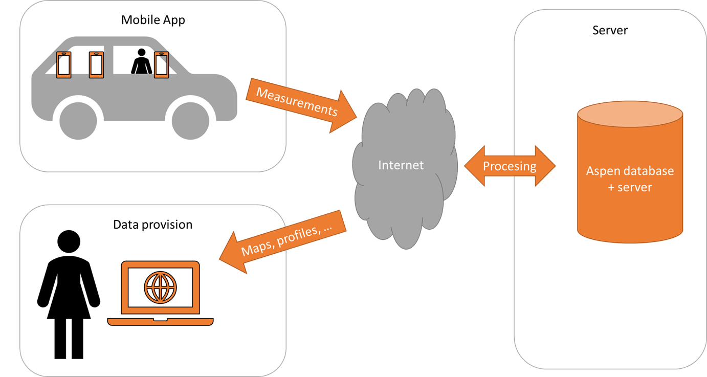
A dedicated online system OnKo3 provides the results as interactive maps, dynamic profiles or video frames. All these views are synchronized and can be browsed by clicking or using network localization (road number, section, chainage, etc.).
Space Added Value
Satellite navigation is the primary space asset enabling ASPEN project. The pavement condition measurements must have its spatial localization attributed.
As a supplementary space asset, we benefit from the digital surface models. They convey information on the grade of the road and facilitate the virtual reorientation of the smartphone data.
Current Status
We are in close contact with seven road administrations that represent different categories of customers.
Four of them are Polish organizations:
- regional road authorities (in Katowice and in Olsztyn)
- district road authority (in Braniewo)
- urban road authority (in Rybnik).
Three are German:
- urban road authority (Lübeck)
- district road authority (Viersen)
- district road authority (Groß-Gerau)
We have successfully deployed the ASPEN system in German city Lübeck to survey 1200 km of sidewalks and bike paths.