
Objectives of the service
The ASAP service aims to deliver in a ‘one-stop-shop’ approach reliable information to actors in the Polish agricultural market to optimize the production, reduce input costs, and increase income.
The service aims to deliver the following information:
- Assessment of crop conditions before winter, based on analyses of biomass, temperature and NDVI. The above conditions determine the amount of fertilizers required in particular plot fragments.
- Based on several years of observations, indication of start of the growing season and recommendation of the best period for fertilization,
- Assessment of nitrogen, soil moisture and biomass in phase BBCH 30 of vegetation growth, recommendation of fertilizer amounts, recommendation of additional measures,
- Assessment of vegetation condition in phase BBCH 40 and suggestion of particular correction measures in order to achieve the highest yield.
Yield prognosis in phase BBCH 49 – 55
Users and their needs
Information concerning the assessment of vegetation status and condition, the yield prognosis, the vegetation condition before and after winter, the monitoring of drought and yield reduction prognosis due to unfavorable weather conditions influence significantly the crop production in Poland and have an impact not only on national, regional and local governments and Governmental Agencies but also on companies in the agricultural market (level of food prizes, income from fertilizers’ sale, etc.).
Due to unfavourable weather conditions in Poland (drought, floods, frozen ground without snow cover, etc.) the yield is often reduced. A lack of sufficient advisory information provided to the farmers is observed and the need of reliable, low-cost and actual information is underlined by the users.
Moreover, due to high losses in agricultural production, the government is obliged to pay farmers compensation rates for certain natural events which are considered a significant expenditure from the national budget and any savings of these cost are welcome
In contrast to existing, but dispersed services and advisory/consultancy companies, the ASAP service is intended as ‘one-stop-shop’ service offering comprehensive information which includes the soil and vegetation parameters as well as analyses of vegetation and weather conditions obtained from aerial and satellite data.
The ASAP service targets the following groups of users:
- Individual farmers
- National, regional and local governments
- Governmental Agencies such as Agency of Restructuration and Modernization of Agriculture, Central Statistical Office,
- Fertilization producers and distributors
- Precision Agriculture Machinery Distributors
The country targeted by the ASAP services is in the first instance Poland.
Service/ system concept
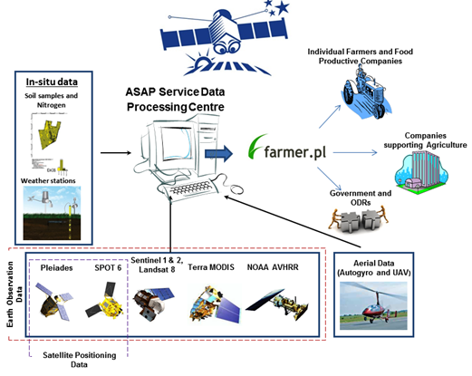
The related System consists of several building blocks: the ASAP Service Data Processing Centre located in the Institute of Geodesy and Cartography will be designed to collect in-situ and meteorological data as well as satellite data, and processing the data. The resulting products will be stored on the Service Server maintained by Farmer.pl. The products will be distributed to the customers through individual accounts.
The Service will be delivering both: free of charge and commercial products. Products which would not require any payment will be presented on the main page of the Service Portal on Farmer.pl, while the products which will need to be paid for will be available on individual accounts.
The Proposed Service will be offering the following Portfolio of Products: basic products supporting farmers in the field management and reporting processes (area of the plots, recognition of crops and precise area of crops), consultation on the most demanded issues (most appropriate time of fertilization in relation to weather, soil moisture and crop growth conditions, the condition of crops after winter and the areas of frozen vegetation; indication of corrective actions or support in application claims for insurance) as well as advanced knowledge and digital maps on: soil characteristics and content influencing the water regime and nitrogen content, nitrogen content in the soil; yield forecast and amount of the fertilizer which need to be applied on the homogenous polygons in the field.
Space Added Value
The proposed products are based on in-situ and satellite based measurements in order to deliver reliable and complete products. The Service is designed to apply multisource in-put data, such as: Earth Observation satellite data from various satellites (optical and microwave (S1, S2, SPOT, Landsat), aerial data from autogyro and UAV, and in-situ data..
Satellite navigation systems and data are required for the development of digital maps ready for implementation on the tractor computing system, as well as positioning of data collected with aerial platforms .
The combination of multiple source remote sensing data and navigation systems with the interdisciplinary experts is designed for delivery of comprehensive products for a wide spectrum of Users.
Current Status
Starting in April 2014, the feasibility study has been completed successfully in October 2014. User requirements have been collected and consolidated, the service provision scheme has been defined, and the viability analysis confirmed the commercial viability. The consortium intends to proceed with a Demonstration Project under ESA’s “Integrated Applications Promotion” (IAP) programme.