Objectives of the service
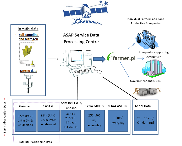
The ASAP System is designed to process Earth Observation, meteorological and in-situ data derived from various sources. The System is able to process the following remote sensing data: MODIS AVHRR (source: NASA), NOAA AVHRR (obtained from IGiK’s satellite receiving station), Sentinel 1 and Sentinel 2 data (European Space Agency), High Resolution Satellite data (commercial distributors) and very high resolution, aerial imagery data delivered by the ASAP partners and in-situ data on the ground.
There are six interlinked and complementary subsystems in the ASAP System: (1) Subsystem for MODIS AVHRR satellite data processing, (2) Subsystem for NOAA AVHRR satellite data processing, (3) Subsystem for high resolution satellite data processing, (4) Subsystem for Very High Resolution and aerial data processing, (5) Subsystem for in-situ data processing, and (6) Subsystem for product distribution and promotion.
The products delivered by the ASAP System are divided into two main groups: free of charge products, and commercial products delivered on demand.
The following products are delivered operationally by the ASAP System on the basis of satellite and meteorological data:
- Maps of homogenous polygons (once per year).
- Continuous monitoring of crop conditions on the basis of Sentinel 2 satellite data (with the possibility of also using Planet Labs data).
- Monitoring of snow cover and surface temperature on the basis of MODIS satellite data, relationship of the derived information to individual fields, and delivery of a report for preliminary forecast of the risk of crop damage due to frost.
- Development and delivery of maps of problematic areas on a monthly basis in geotiff and kml file format in order to enable farmers to identify lower productivity of crops in parts of the field.
- Monitoring of drought on the basis of NOAA AVHRR data and relationship to individual fields.
- Weather forecasts on hail, storm, high precipitation and frost, and actual meteorological data on temperature, precipitation and wind speed.
- The following products are designed to be generated on demand by Users on a commercial basis:
- Maps of crop type – the maps of classification of four main types of crops: winter and spring crops, rape and corn, developed on the basis of Sentinel 1 and Sentinel 2 satellite data.
- Reports, elaborated in the form of Excel files.
- The designed System and Service is aimed at a wide group of users and customers covering various sectors of agriculture. The main needs expressed by the Service’s stakeholders are for a reliable, comprehensive service offering information supporting crop production based on multi-source data, as well as a service for drought prognosis and yield assessment / reduction. The ASAP System aims at addressing these needs in order to offer operational solutions for delivering fast and reliable information on crop conditions and predicted yields.
Users and their needs
The Users have been initially identified and selected as a result of the previous IAP Feasibility Study, and can be divided into four main segments:
- S1: The Food Production Sector such as farmers and food production companies.
- S2: Government Agencies supervising the agricultural market.
- S3: Companies supplying the Agricultural Production Sector such as Producers/Distributors of Fertilisers and Agricultural Equipment.
- S4: Companies providing services to the Agricultural Production Market such as Insurance and Consulting Companies.
The first and fourth of these groups are recognized as likely to be the most profitable clients of the ASAP Service.
Service/ system concept
ASAP products are offered in two ways, as freely available and chargeable products. The freely available products are available to all interested Users in the Service portal on the Farmer.pl website, and are rather general in character – these products have national and regional scale, but can also be used by individual farmers. The chargeable products are delivered to paying customers via a mobile app “Agro-Assistant”. The ASAP customers are given individual protected accounts, where all the products and analysis purchased by the customers are stored and displayed. The Agro-Assistant App offers the following ASAP products: Maps of crop conditions developed on the basis of Sentinel 2 satellite data (NDVI index) for each cloudless acquisition of Sentinel 2; Maps of water content in crops on the basis of Sentinel 2 satellite data (NDII index); Maps of soil management zones (once per year); Maps of problematic areas generated on the NDVI index maps from the three most recent Sentinel 2 images; Maps of alerts based on NDVI index decrease between the current and previous image; Maps of potential yield obtained from the monitored field and the fertilisation dose. Subscribers can add boundaries of Regions of Interest (ROIs) to obtain a more detailed analysis. For ROIs, farmers receive maps of crop condition as well as the maps of alerts, and if carefully selected can enable farmers to control the crop condition in the most vulnerable areas.
As well as maps, a graph demonstrating the value of the NDVI index over a defined period of time is generated, as well as the weather forecast and accumulated weather data. The User can also add information on the current crop sown in the field and any performed treatments.
Space Added Value
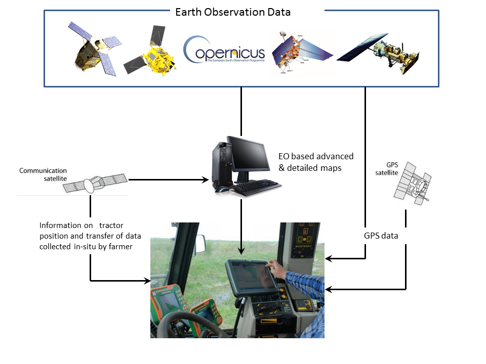
The ASAP Service is designed to use two types of Space Assets: Earth Observation and Satellite Navigation. The EO and Satellite Navigation data are combined in order to develop geo-referenced maps for agriculture purposes. Satellite Communications could additionally be used for real-time data transfer from the tractor.
The proposed products are based on a combination of data: in-situ and satellite-based measurements in order to deliver reliable and effective products; satellite data is obtained from various satellites, both optical and microwave (Sentinel 1, Sentinel 2, Planet Labs, MODIS, NOAA AVHRR).
Current Status
The ASAP System performance and products have been tested in two growing seasons 2016/2017 and 2017/2018 targeted towards Users from Segments 1, 2 and 4.
In response to the needs of insurance companies, the ASAP team has developed a prototype of a comprehensive monitoring system for crop condition after negative overwintering of crops, based on synergistic use of high resolution optical and radar satellite data (Sentinel 1 and Sentinel 2), low resolution satellite data (MODIS and NOAA AVHRR) and meteorological data.
On request of the National Supporter of Agriculture agency (KOWR) in Poland, the ASAP team has also developed a prototype Drought Monitoring system, based on Sentinel 2, NOAA AVHRR and meteorological data.
The ASAP System is currently designed to deliver:
- free of charge services offered via the existing asap.farmer.pl platform;
- commercial services to be offered via a mobile application “Agro-Assistant”.
The mobile application approach is the result of limited capabilities of further upgrading the asap.farmer.pl portal, due to architectural limitations of the website and at the same time higher expectations of Users for portal functionalities and the need for commercial provision of the services.
The Agro-Assistant Mobile App was released in May 2018. The app was developed by the company “Sustainable Innovation” which was established by Michał Wyczałek, owner of GEOMATIC (one of the ASAP partners). A contract has been signed with Timas Agro Polska (a fertilization producer and distributor company), for purchase and delivery of the mobile app to the company’s clients for ASAP products for 20,000 ha in the season 2018/2019.
ASAP products have also been delivered on a commercial basis to other Users such as a fertiliser producer and distributor and to the insurance industry.
The ASAP Demonstration Project is now completed (with a CCN in preparation).