
Objectives of the service
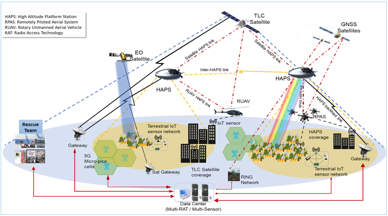
ARIES project aims at providing an efficient service for Prevention, Monitoring and Response of Wildfire and Landslide emergencies, with a particular focus on area of the municipality of L’Aquila. A System of Systems composed by satellites (both for Earth Observation and for Telecommunication), Terrestrial Networks (5G/4G), HAPS, next generation IoT Sensors and Drones (both low-altitude and high-altitude) will be proposed, together with a Data Center hosting the control algorithms for an Optimal Planning for Monitoring system and for a Decision Support System for Emergency Response, while also focusing on the reliability of the communication network through a Multi-RAT Network controller algorithm, that makes use multiple available radio paths (even if they belong to different radio technologies) to guarantee the required QoS levels for the service. The feasibility of the proposed system will be validated by extensive simulations of the over-mentioned components and control algorithms.
Users and their needs
End-users are the Italian Fire Brigates, the Municipality of L’Aquila and Servizio Emergenze di Protezione Civile e Centro Funzionale D’Abruzzo which have the following needs to be satisfied:
-
Receive accurate and timely information from the field in order to correctly evaluate the emergency situation.
-
Gather precise information on the territory, including vegetation status, terrain slope, presence of inhabited centers, etc.
-
Make accurate forecasts (short to very-short term) on future wildfires and landslides in order to plan interventions aiming at mitigating the emergency risks.
-
Make accurate fire propagation and landslides evolution models to better coordinate the emergency personnel in the emergency phases.
-
Provide very reliable communication with sensors on the field (ground IoT sensors, Drones, …) while also maintaining acceptable QoS levels for the different types of data.
-
Providing an integrated dashboard to represents the data coming from the field to the emergency teams in an effective way.
Furthermore, the proposed system architecture allows end-users can be easily extended both to other categories of users in the emergency management market segment (i.e., Civil Protection) and to other market segments (both public and private users).
Service/ system concept
End-users will get several innovative benefits from the proposed solution:
-
multi-RAT/multi-sensor resilient solution: system optimized to manage heterogeneous resources to guarantee prevention, monitoring, detection and response to emergency situations.
-
Next Generation IoT network designed for optimal and reconfigurable sensors deployment offering overall monitoring system robust against cyber attacks.
-
Algorithms for optimal IoT sensor and drone placement that exploits data available from EO satellites, high-altitude/low-altitude drones and ground IoT sensors.
-
Data Center capable of multi-source data fusion to plan specific monitoring alerts.
-
Multi-RAT network solution: to provide an adaptive network resource management to guarantee a resilient service according to the required QoS levels.
-
A Decision Support System for emergency response operations providing one or more suggestions according to the specific emergency situation.
The architecture proposed above ensures that all the end-user needs can be satisfied, and the combined use of latest technology permits to automatically detect the environmental disaster within seconds, monitor it, prevent further damage, and provide support to emergency personnel as well as analyse the reasons that caused the disaster.
Space Added Value
The prevention and monitoring services exploit Satellites for earth observation (EO) in LEO orbit, equipped with SAR-type on-board sensors, which allow to collect and process Big Data (GEO-referenced) in Data Center. These collected data (together with IoT sensor data) are used by the rescue team (Italian Fire Brigades and Abruzzo Civil Protection) to predict in the shot/very-short time emergency situations, as well as to know, in real time, the exact location where the emergency is occurred and the extent of damage to choose the most suitable countermeasure for each case.
In view of its extremely critical nature, communication with the emergency teams is supported not only by terrestrial 5G infrastructure but also by TLC satellites and drones (RPAS, HAPS) to guarantee reliable and fast communications, exploiting the availability of multiple communication paths, and to increase the overall robustness of the system. The proposed solution defines algorithms to control a multi-Radio Access Network (RAT), combining both terrestrial and satellite Radio Access Technologies to guarantee the over-mentioned performance, also taking into consideration the required QoS levels.
Moreover, TLC satellites allow coverage of very large areas that are difficult to access by terrestrial communication infrastructures.
Current Status
The project member Telespazio (TPZ) organized a workshop with the End-Users, the relevant Stakeholders and the Sponsoring Partners to gather the User Needs and to involve the participants to the project activities. In order to gather the mentioned information, Telespazio prepared a questionnaire for the End-Users and the other interested parties, whose results are reported in document D1 – Customer Engagement and Value Proposition Definition.
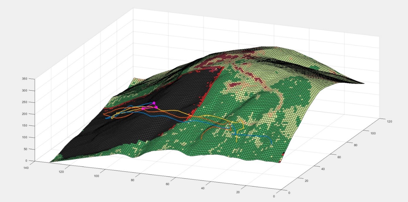
CRAT provided a set of state-of-the-art algorithms, in particular for wildfire prediction making use of Deep Neural Networks, fire propagation models and risk-aware Drones Formation Control for monitoring and response purposes, for multi-RAT network resources optimization and a multi-RAT simulator to be used in the validation of the multi-RAT Controller algorithms. The obtained results are reported in document D2 – Technical Feasibility Assessment.
The ARIES team prepared a Business Plan that justifies the economic viability of the project and the sustainability of the final service when it will be deployed on the field and will be available to the End Users and the relevant Stakeholders. The results are reported in document D3 – Viability Assessment.
The ARIES team demonstrated a set of standalone PoCs to show the capabilities of the proposed system components like the Multi-RAT Network Control system and the Fire Detection algorithms within the Fire Simulator and their relationship with the identified User Needs and User Requirements. The results obtained are reported in document D4 – Proof of Concept.
The project reached the Final Review stage and, given the positive results obtained, the ARIES Team prepared an Outline Proposal for a Demonstration Project to provide evidence of the proposed system in an operational approach.