Objectives of the service
Photo credit: T. Krupnik/CIMMYT. https://www.flickr.com/photos/cimmyt/8098412620/
Food Security is a fundamental concern for all societies and governments around the globe. Existing modern agri-technologies enabling to mitigate production risks or the corresponding knowledge of handling is notably not available to the majority of smallholders in emerging and developing countries.
Various stakeholder in the supply chain are suited to improve their situation, either by providing financial support (government, finance sector) or by boosting their productivity due to commercial interests (e.g. buyers doing contract farming). Key for all these stakeholders is to understand and manage the production risks of the small holdings. Our services aim to efficiently monitor these agricultural production risks.
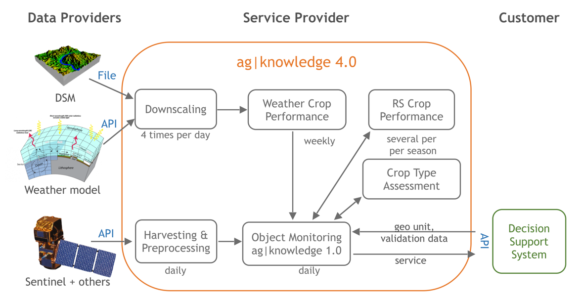
Ag|Knowledge 4.0 is a novel concept of an online platform providing the required integrated analytical services and indicators for agricultural risk monitoring. This middleware platform is designed for live integration into the workflows and decision support systems of the stakeholders and farmers. Thus, enabling various players in the food security business chain to use satellite services within their local context, deriving higher level economic variables and perform knowledge distribution.
Users and their needs
Agricultural production involves a great variety of stakeholders, having different roles in the supply chain such as commercial producers, subsistence farmers, buyers and processors, input suppliers, insurance companies, banks and governments.
All these stakeholders have a common need to manage major risks related to agricultural production or to the implementation of policies. These risks are mostly related to weather and climate changes, pests and diseases, lack of farming knowledge or opportunistic behavior. However, the accessibility of actual information to better manage the risks in these countries is usually poor. Hence the main need is to obtain timely information about:
- actual crop growth status and
- expected and actual yield and quality
by at the same time
- covering large areas
- with many mostly small parcels
- at relatively low costs
Within the project we focus mainly on contract farming and the financial sector in support of smallholders.
The project targets emerging economies with a particular focus on India, the world second largest agricultural producer with 140 million farmers. Additionally, it is planned to do a service demonstration in Europe or Africa.
Service/ system concept
The service system covers the environmental key factors involved in food security risks: impact triangle weather/climate, land & soil quality, management of crop commodities and input resources (water, nutrients, pesticides, etc.).
Ag|knowledge is a novel online platform providing integrated analytical services and indicators for agricultural risk management. The services aim to be robust, simple to use and transferable to other regions. The middleware platform is designed for live integration into the workflows and decision support systems of the stakeholders by local ICT integrators. The final set of services will contain:
- Basic Crop Monitoring Service: Allow to obtain regular crop status information
- Weather Monitoring Service: High resolution now-cast and forecast.
- Crop type area assessment service: Allow to verify crop types at field level and obtain local crop maps.
- Crop performance indicators: Remote sensing and weather based crop performance indicators allow to identify crop stages, crop health, anomalies, compare locations and fields, better assess and validate yields and quality.
Space Added Value
We are using open remote sensing satellite data originating from Copernicus mainly Sentinel 2, Landsat 8 and MODIS (USGS). We are directly deriving EO variables and products needed for the services. RS data is suited to leverage non-space technologies since it allows to extrapolate findings on the ground. Competing with non-EO technologies the added value is objective and continuously updated information at low costs by covering up to 100% of the area requested.
Information derived from weather satellitese.g. Meteosat and GOES as they are exploited by global circulation forecast systems is of major importance. Such space data is essential to permanently re-calibrate circulation model. Via WMO data server a global weather station network is typically involved but cannot substitute satellite data due to different variables collected and due to the spatially detailed coverage of the satellites which cannot be achieved via weather stations.
GNSSis involved as space technology at different components. Next to the geo-coded weather stations being connected via GPRS and GNSS modules (WMO, private) crop and soil reference data in the fields will be collected by stakeholders via GNSS equipped smartphone devices. Other purpose for GNSS is mapping various boundaries.
Current Status
The activities for the Demonstration Project started in February 2019. In November of the same year the Prototype Acceptance Review (PAR) has been passed. In March 2020 we reached the Critical Design Review (CDR) and in July the Ag|Knowledge 4.0 platform has been released at FAT/SAT. Weather and satellite data updated daily covers practically all India and some areas in Africa. The services have been tested, calibrated and validated in an intensive pilot phase lasting from August 2020 to March 2021. In total 9 pilots have been conducted throughout India and due to COVID-19 also in parts of Europe.
Now the services are transferred from Demonstration phase to the operational and commercial stage. First users have signed up to the services. For more information please refer to: https://sites.google.com/site/geocledian/home/product-overview or contact us at info@geocledian.com.