
In recent months Scotland has seen a number of high-profile landslips, including the train derailment near Stonehaven that tragically led to loss of life, and multiple road blockages along the famous A83 Rest and Be Thankful pass through the Highlands.
Whilst these sites are actively monitored and managed by geotechnical engineers, there is a role for Space in delivering information that can’t be obtained from solely land-based equipment.
‘LiveLand’ is an ESA Space Solutions project that has developed innovative ways to monitor, measure and assess geological hazards by integrating Earth Observation data and Global Navigation Satellite Systems (GNSS).
The service combines data collected from a number of space and geological assets: LiveLand is currently working with Network Rail (Scotland) and Transport Scotland, the organisations responsible for the rail and road infrastructures of Scotland.
- Earth observation radar data from ERS, Envisat and Sentinel-1 satellites
- Weather forecasting from earth observation radar satellites
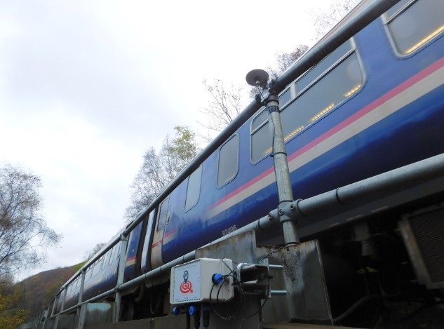
- GNSS technology through the use of cost-effective GNSS devices which continuously monitor the smallest of movement of critical infrastructure
- Geology, geomorphology and landslide susceptibility from using the British Geological Society’s GeoSure dataset.
The current and final stages of Liveland is increasing the technology readiness level of the GNSS devices, branded as ‘STICKs’.
These devices are in situ sensors that combine GNSS and IMU (Inertial Measurement Unit – or ‘motion sensor’) technologies to determine long-term movements to millimetric accuracies and to provide immediate alerts when sudden larger movements are detected.
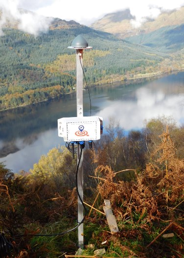
Space, including Galileo, enables these accuracies and provides the geodetic reference frame (the accurate measurement of geometric shape, orientation in space and gravitational field) which is a unique selling point over other sensors. Using this common frame, STICK devices are intrinsically tied to each other, allowing individual, local and regional analysis of the geotechnics.
LiveLand has already been successfully demonstrated in certain ‘at-risk’ sites across Scotland.
“The important thing here is that space can really offer something,” says Roberta Mugellesi-Dow, Technical Officer at ESA.
“Landslide strikes are unpredictable with multiple causes – space data can provide hugely valuable information such as the structure of the soil, amount of rainfall and other critical factors which could help to prevent fatal accidents.” Roberta Mugellesi-Dow, ESA
William Roberts, current LiveLand Project Manager, and Operations Manager with GMV NSL says: “There is no other service currently available that provides a similar integrated solution for providing network-to-local level for the prediction, monitoring and alerting of landslides. LiveLand can play a crucial role in helping to monitor the UK’s physical infrastructure that is being exposed to an ever-increasing level of risk.”
ABOUT ESA SPACE SOLUTIONS
ESA Space Solutions is the go-to-place for great business ideas involving space in all areas of society and economy. Our mission is to support entrepreneurs in Europe in the development of business using satellite applications and space technology to improve everyday life. Our programme is designed to provide multiple entry points such as ESA Business Incubation Centres (ESA BICs), ESA Technology Transfer Broker Network, and ESA Business Applications programme. Funding typically ranges from 50KEuro to 2MEuro and supports everything from space technology transfer, early stage incubation programs, feasibility studies to large-scale demonstration projects.