

OPPORTUNITY
The importance of clean and safe management has become central not only to the hydrocarbons industry but also to other resource industries such as water and electricity, especially in the context of pipelines and transportation infrastructure. Indeed, given their fundamental importance of these resources to everyday life, it is essential to keep them clean and safe.
Technology evolution, such as big data, IoT, artificial intelligence and autonomous vehicles offers a wide range of opportunities for European industry to come up with new solutions enabled by Space.
ESA business applications is therefore launching a new Invitation to Tender, to assess the technical feasibility and economic sustainability space-based services addressing the planning, management and impact assessment of installations and transport systems for hydrocarbons and other natural resources such as water and electricity. Such services are aimed at ensuring personal safety, environmental sustainability, long-term economic growth and resource security. Any resulting studies are also intended to establish the roadmap for service implementation through one or more potential follow-on demonstration projects.
For the purpose of this study, ESA Business Applications has undertaken discussions with several key stakeholders from the hydrocarbons, water and electricity pipelines communities, who will provide feedback to the study results and contribute with inputs towards potential follow-on demonstration projects. In particular, a collaboration has been established with the Mexican Space Agency with the aim of identifying needs and requirements that are of high relevance to a number of Mexican stakeholders. To this aim, the Mexican Space Agency has engaged with the user communities, such as CONAGUA (managing and protecting the country's water resources) and PEMEX (the Mexican oil company that supplies, among others, natural gas and liquefied petroleum gas), in order to gather specific requirements addressing their respective areas. These are provided as inputs to this activity.
KEY FOCUS AREAS
Potential services should:
- be enabled by Space, to support the management of pipeline infrastructure throughout their lifecycle. This includes the use of archive imagery and elevation data during initial planning and construction stages and radar technologies for the monitoring during the operational phase.
- contribute to a clean and safe management of the hydrocarbons industry and other resources as water and electricity. Operators are aware of the risks that a pipeline poses to the surrounding public and environment; and as a consequence several steps must be undertaken to ensure that the risks are kept to the lowest level that is reasonably admissible.
The following scenarios have been identified as key focus areas:
- Discovering underground resources
- Pipelines development planning (water, hydrocarbons and electricity).
- Monitoring pipeline infrastructure.
- Detecting leakages and damages
In addition to the monitoring of the pipelines, the advanced processing of geospatial data from space and other sources could enable operators to perform a number of tasks: plan installations taking into account environmental impact; categorize each segment of pipeline depending on its proximity to population; identify areas of concern; assess the risk of impact on that population in case of leak or explosion; prioritize monitoring, maintenance and inspection activities depending on the risk level.
Space technologies can play an important role in conjunction with the deployment of novel technologies (e.g. 5G) in the monitoring and maintenance of pipelines. 5G systems, the next step in the evolution of fixed and mobile communication, could have a central role in the management of hydrocarbons and other resources. 5G in fact will permit meeting a set of requirements (i.e. high data-rate, wide coverage, high throughput, high reliability) which are fundamental for enabling services relying on communication means for relying data with high availability and in a secure manner from remote locations. This will be needed in the case of monitoring and management of assets deployed over large and remote areas. With the advent of 5G, a new generation of communications networks will be deployed, enabling the emergence of new applications and new business models. Also, it is expected that sensor networks and IoT technologies will rely massively on the new capabilities offer by 5G networks.
The utilization of big data analytics, image-recognition algorithms, crowd-sourcing, etc. offers a wide range of opportunities for new services.
VALUE OF SPACE
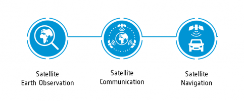
EARTH OBSERVATION (SatEO)
Earth Observation imagery and data are valuable for providing monitoring of the environmental condition of the area of interest. Data measured with radar and optical sensors can be used as input for modelling the current condition and for forecasting air quality, water quality and soil conditions. Multispectral bands data including the near-infrared band, as well as Synthetic Aperture Radar (SAR) data can be used for the detection of anomalies in the extremely large areas of pipeline corridors, including ground subsidence; multispectral satellite images can be used to further zoom-in on any anomalies that have been detected with the radar. Novel concepts could be used to process remote sensing data (including meteo data) to detect dispersion effects in the atmosphere and in the ground because of pipeline leakages. Altimeter data from Sentinel-3 data can be used to detect the level of water in reservoir. Further, SatEO data, in combination with demographic and other geospatial data, can be used to support the planning of the infrastructure, as well as the assessment of the impact on environment and population. Weather data are precious to monitor environmental conditions around areas of interest. Stack of historical and current SatEO images can be used to show the long-term effects on the environment surrounding the pipelines.
SATELLITE COMMUNICATIONS (SatCom)
Satellite communications offer a unique alternative to the transmission of data through the terrestrial internet with the coordinating centre to and from remote locations where there is no terrestrial network or to cope with a large demand for bandwidth, e.g. for live streaming of images. Used as a primary communication means or as back-up to terrestrial networks, Satcom can therefore enhance communication network robustness and communication resilience.
SATELLITE NAVIGATION (SatNav)
Satellite navigation (GNSS) allows to provide an accurate location to track & trace deployed field teams, to guide to the locations of interest, to operate and steer robotic devices, to navigate Remotely Piloted Aircraft Systems, RPAs, and to geo-locate samples taken in the field and to generate a precise timestamp. SatNav can also provide accurate geolocalization of sensors data to be used for maintenance operations and location of incidents, detection of anomalies. RPAs can be used as complementary solution for monitoring purposes to fill the gap between space-borne acquisitions and when a higher spatial resolution is required.
Webinar
- 19/08/2019, 15:00 CEST
- 29/08/2018, 15:00 CEST
![]()
WHAT WE LOOK FOR
We offer funding and support to companies, both for business case assessment and for the development of new, space-based services related to the safe and clean management of water, hydrocarbons and electricity pipelines. Our offer includes:
• 100% zero-equity funding up to €200K per activity;
• Technical & commercial guidance;
• Access to our network and partners;
• Use of the ESA brand for your service.
WHAT WE SEEK
We are looking for teams that have identified an attractive market opportunity with real potential for engaging customers. Motivation, business experience and domain expertise are all important features. We want to hear about your commercially viable, technically feasible business ideas that involve either space technology or space data. For this call, companies residing in the following Member States will be eligible to apply: AT, BE, CH, CZ, DE, DK, FI, FR, GR, IE, IT, LU, NL, NO, PL, PT, RO, SE, UK. See also the information below on obtaining letters of support from National Delegations.
ESA TENDER INFORMATION
Responding to an open competitive Invitation to Tender (ITT) requires the submission of a Full Proposal. The submission of the Full Proposal initiates the evaluation process according to ESA regulations and procedures.
The consequential evaluation of proposals results in a recommendation for a winning bid. If several proposals of sufficient quality are submitted, targeting different and/or complementary aspects, the Agency reserves the right to place parallel contracts for each of the open competitive ITTs, in coordination with the relevant national delegations (and with the other partners involved in the case of external funding).
For the fully detailed Proposal Guide on competitive ITTs click: Open Competition
This feasibility study is 100% zero-equity funding up to €200K per activity.
Registration as Bidder
The Prime and all subcontractors must register as potential bidders via esa-star, prior to downloading the official tender documents from EMITS AO9937 from September 2nd 2019 and submitting the Full Proposal. The registration process needs to be started as soon as possible, as it will take time to complete.