Objectives of the service
Knowing the origin and life cycle of product constituents is important for both retailers and consumers. Independent certification provides manufacturers with confidence about their environmental and social integrity.
The international standard developed by Forest Stewardship Council (FSC) provides a globally accepted route to forest management certification. FSC’s mission is to “promote environmentally appropriate, socially beneficial, and economically viable management of the world's forests”.
However, forest certification has a number of challenges, especially the reliance on limited field inspection and the extrapolation of limited observations to support certification decisions very large forest areas. Increasing either the intensity or frequency of certification audits would be prohibitively expensive and unacceptable to the forestry community. Another solution is required.
TransparentForests aims to overcome these limitations, by allowing relevant stakeholders to visualise and share key management data with each other, in the context of independent customised date stamped maps and change maps, where the dates reflect the audit period. It also aims to provide a communication platform allowing stakeholders to create and safely share information.
TransparentForests objectives were to:
- Support to forestry management
- Raise quality and reliability information used in forest audits
- Increase transparency and credibility of process;
- Mitigate costs across the certification service chain
Users and their needs
The client is the Forest Stewardship Council.
FSC needs a practical solution to meet the following operational challenges and goals:
- Maintain and improve the quality of certificates it issues especially on large forest operations, where physical access for inspection teams are limited due to time constraints and costs
- Facilitate continued expansion in the area of FSC certified forests, without reduction in credibility or quality of the certificates issued
- Facilitate stakeholder engagement
- Increase transparency to enhance and protect brand value
Certification Bodies and the Accreditation Body need:
- Independent and up to date maps of certified areas to support inspections as they currently rely on data and information provided by Certificate Holders.
- Greater global consistency in the information base supporting certification decisions.
TransparentForests provides Certificate Holders with a tool that links them directly with the Certification Bodies and stakeholders and facilitates audit preparation and execution. They can also request state of the art map products (e.g. very high resolution land cover maps or products to measure timber volume) to support forest management activities.
Stakeholders (NGOs, Indigenous Peoples, Forest Communities and the general public) can use TransparentForests as a new channel to engage and provide critical input on social and environmental issues.
TransparentForests has to have global coverage as FSC certified forests are all over the world.
Service/ system concept
TransparentForests utilises EO and GNSS data. The diagram below presents an overview of the TransparentForests system architecture.
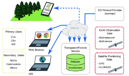
The online service at the centre of the architecture is the data store, interacting with the user interfaces and the Earth Observation product provider.
TransparentForests provides three user interfaces: TFWeb, TFDesktop and TF Mobile. TFWeb is a WebGIS application, accessed through a web browser allowing Certificate Holders to upload management data, Certification Bodies to plan audits and other stakeholders to contribute to the process.
Sarmap generates TransparentForests Land Cover maps of the Certificate Holder’s certified area as near as possible to the planned audit date. These and Change Maps showing changes with previous annual maps, are used by Certification Bodies in planning/performing field audits.
TF Mobile allows users (particularly Certificate Holders and Certification Bodies) to visualise their location in the context of land cover maps & vector datasets, comments, notes and other related georeferenced data. The simple interface supports navigating and adding geo-referenced field information (e.g. photos, comments or observations).
TF Mobile does not require an internet connection while operating in the field as data is cached before entering the field and synchronised with any edits / new field data afterwards.
Space Added Value
TransparentForests provides Standard land cover maps using free of charge multi-temporal and multi-sensor EO data (Sentinel 1 and 2, and Landsat 8) in a process outlined below.
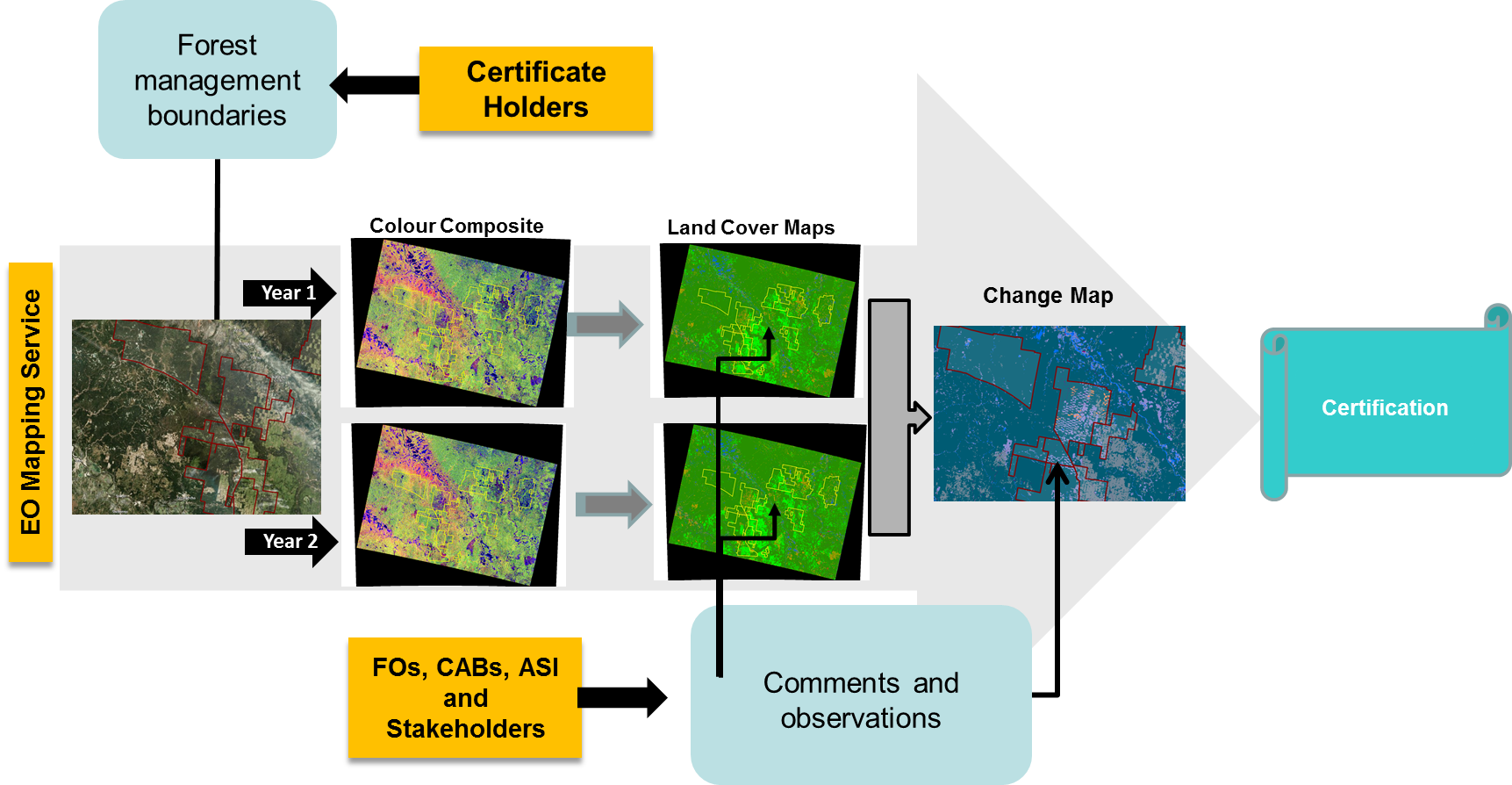
These Land cover maps, are combined with Management data (outer boundary, felling areas, Conservation areas) providing Certification Bodies independent data on location and extent of planned and unplanned management activity, between two map dates (23 May 2015 and 25 May 2016) as shown below.
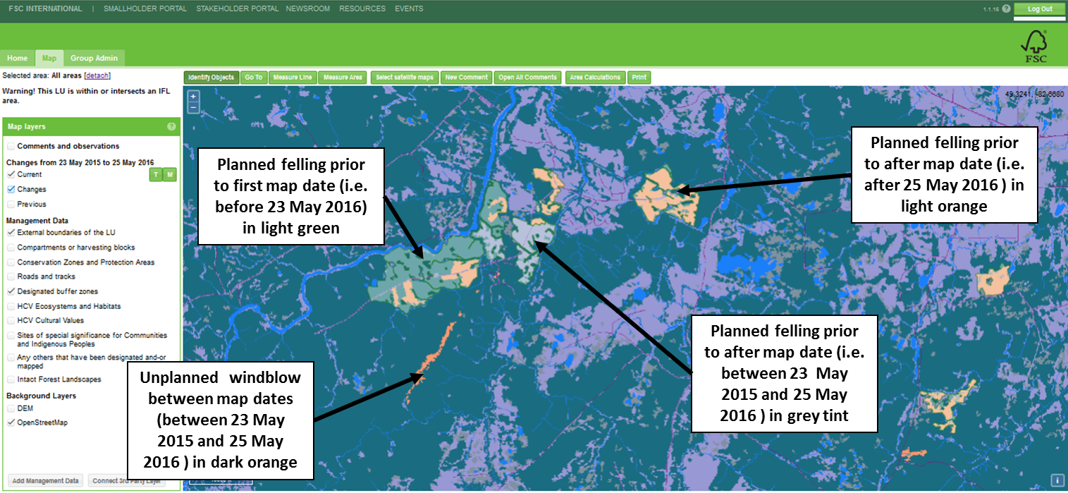
TransparentForests supports registration of geo-referenced data, created via TFWeb or in the field via TFMobile. For example, this allows:
· Certificate Holders and Certification Bodies to identify and share points of interest (e.g. planned felling coups, protected biotopes, roads etc)
· Indigenous Peoples to register rights or interests, and Certification Bodies to view these in respect of land use and changes
· Certification Bodies to record evidence of field inspection routes
· Stakeholders to communicate georeferenced comments or observations with selected parties (see below).
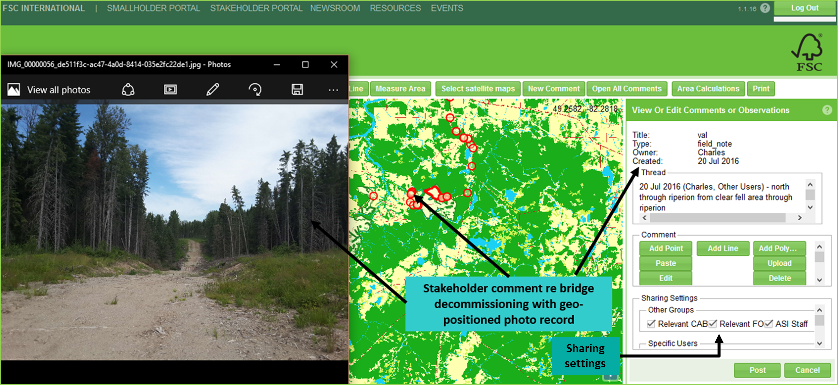
Integrating these date-stamped Standard maps with boundaries, geo-referenced field information, comments or observations, provides a new tool to facilitate better forest management and stakeholder engagement, enhancing the credibility of the certification process.
Premium Maps (e.g. for timber volume), generated from commercial sensors, are provided on demand.
Current Status
The Feasibility Study which started on 22 December 2012 was successfully completed in January 2014. FSC agreed to initiate and support a Demonstration Project.
The Demonstration Project started in October 2015 and is now complete, the project having successfully met all milestones. The Demonstration Project carried out 5 large scale field demonstrations around the world. An analysis of user reactions from these trials was carried out, along with an assessment of the potential impact of TransparentForests on the credibility, transparency and costs across the certification delivery chain. Feedback from trial participants has been very positive across most metrics and many feature improvements were identified.
The Service Providers have also completed an assessment of the costs of rolling this service out across FSC. FSC has expressed satisfaction at the outcome of this phase and is considering implementation strategies.
The Service providers are also discussing service extensions with partners in other sectors.
Prime Contractor(s)
Subcontractor(s)