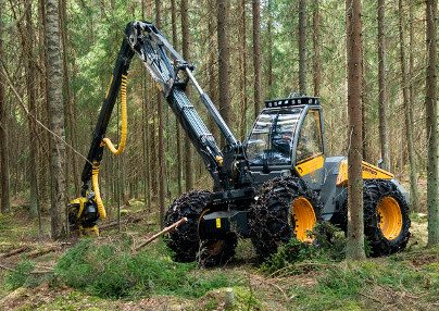
With the support of ESA under the ARTES Programme, Irish company Treemetrics developed an innovative system that uses space and ground assets to map forests and monitor tree-harvesting machinery (see: Trees tell their own story to satellites, April 2012). In a follow-up activity, likewise supported by ESA, the company has extended the original system for use with forwarder machines as well, the vehicles which collect stacks of partially processed timber in the forest and convey it to the roadside, from where it is transported to sawmills.
 By means of a device with hybrid satellite/terrestrial communications and GPS that is installed in the cab of a harvesting machine, the original system provided detailed mapping information to the operator via an in-vehicle display specifying the trees to be felled. It reported location and progress in (near) real-time to a central web-based reporting and administrative system. In an extension to the original ARTES 3-4 project, the system has been enhanced so that operators of the forwarder machines are given in-vehicle display mapping and other information to facilitate finding and transporting the logs that the harvesting vehicles have partly processed and stacked at specified locations. The new system was developed and tested on six forwarder vehicles in over a period of 2 months and has proven to work very well, with user satisfaction rating above 90% according to Treemetrics.
For the independent owner-operators of the harvesting machinery, the Treemetrics system provides detailed navigation capabilities as well as security options to help safeguard their equipment. For the forest owners, the system supplies accurate information on logging yields. For the sawmills, it allows for the adjustment of the incoming supply to by conveying to operators the type of timber currently in demand, whether pulp or a higher grade, adjusting output accordingly.
In a related ARTES activity, Treemetrics is developing a system uses satellite navigation and Earth observation data to provide vital insights into the health of forested areas, assisting the owners of forests to identify the areas which are most suitable for harvesting. Satellites provide not only much higher resolution images, but can also be updated more frequently than traditional hard-copy maps, giving landowners highly accurate and up-to-date information.
Commercialisation of Treemetrics' technology is now well under way. The Irish Farmers Association has agreed to jointly co-market the solution to their national membership under the name “iForest”. Green Belt, Ireland's largest private forestry company, has also announced plans to deploy the system nationally to their clients. Coillte are in talks to begin a pre-commercial roll out of the system in a test area by the end of 2014. The system is also being introduced in the United Kingdom with RTFI systems relaying harvester information to some of the largest forestry companies in the UK.
Responding to customer input, Treemetrics is planning to further extend the system to the haulage trucks that collect the timber deposited on the roadsides by the forwarder machines and transport it to the sawmills. This would mean the system could be deployed for the entire timber production chain, making it possible to keep a close account on this valuable natural resource, from the forest where initial harvesting takes place to the forwarding of the logs to the roadside and then as it is hauled to the final processing plant.


