

Objectives of the service
Mitigrate's service tackles the pressing challenges confronting insurance companies and policyholders amidst rising flood-related losses. The primary objectives encompass the spatially informed implementation of Nature-Based Solutions (NBS), sensitivity analysis on satellite image resolutions, and assessing CO2 emission reduction. By leveraging space-based technology and digital twins, Mitigrate strategically applies NBS, reducing the need for building repairs and associated CO2 emissions. The service navigates spatial resolution challenges, exploring machine learning for coherent results with lower-quality satellite imagery.
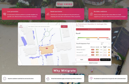
Mitigrate's solution not only addresses financial and insurability issues but aligns with EU taxonomy sustainability goals. It offers tailored flood prevention recommendations, significantly lowering annual average losses, positively impacting key insurance metrics, and boosting customer satisfaction, retention, and Lifetime Value (LTV). The service promotes a sustainable business model by curbing CO2 emissions and fostering resilient communities. In essence, Mitigrate's offering transforms the insurance landscape, mitigating losses, enhancing sustainability, and ensuring resilience for the future.
Users and their needs
Mitigrate’s primary emphasis lies within the general insurer category, spanning underwriters, claims handlers, risk management teams, re-insurance purchasing professionals, and sustainability teams. These key stakeholders play pivotal roles in encouraging policyholders to implement effective flood prevention measures. The overarching goal is to mitigate the financial impact of claims, minimize rebuilding expenses, and contribute to environmental sustainability by reducing CO2 emissions. This strategic focus not only aligns with the promotion of a low-carbon economy but also ensures adherence to the EU taxonomy standards.
Building robust connections with major insurance companies in Norway has been a cornerstone of the team’s efforts, fostering collaboration and understanding within the local insurance landscape.
Additionally, company’s network extends globally, with established contacts and engagements in Germany, Japan, and the United States.
User needs can be summarized in 3 main categories:
-
Access to loss prevention measures, cost and visualization
-
Risk reduction visualization and investment analysis
-
Portfolio risk assessment and sustainability integration
Service/ system concept
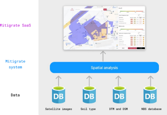
Mitigrate system eliminates the necessity for on-site visits for recommending flood risk reduction measures. By using diverse data sources, including high-resolution geospatial, satellite data, alongside advanced technologies like machine learning, and Nature Based Solutions database, Mitigrate’s system provides insurance companies with a powerful tool. Mitigrate offers a holistic approach that goes beyond risk assessment by recommending specific measures and nature-based solutions (NBS) for each property to mitigate flood damage and associated CO2 emissions effectively. This sophisticated system allows Mitigrate SaaS to recommend tailor-made solutions with precision, factoring in relevant size, location, and implementation costs for individual properties. Furthermore, the service enables insurance companies to align themselves with the EU taxonomy and sustainability goals. By actively promoting the reduction of damage and associated CO2 emissions, insurance companies can demonstrate their commitment to environmental responsibility and contribute to a greener future.
Space Added Value
Earth observation data provide a broad coverage area that enables us to analyse and monitor large scale phenomena. The use of Earth observation data offers the advantage of scalability and transferability. This scalability allows for efficient flood risk management in different regions, saving time and resources. Using Earth observation data as an integral part of the service. They are regularly updated, providing timely and current information.
The analysis workflow relies on Digital Terrain Model (DTM) and Digital Surface Model (DSM) data for spatial analysis, considering terrain characteristics and incorporating surface details to simulate floods accurately. Satellite images, supported by DSM data, are employed to generate LULC maps,
allowing for an understanding of land cover types. Soil type maps are integrated with other relevant data, including land use/land cover (LULC), slope maps derived from DTM, and soil depth maps to determine the optimal locations for implementing NBS. By combining these data sources and employing advanced techniques, the company can enhance flood risk assessment, land cover mapping, and the identification of effective adaptation strategies in order to minimize CO2 emissions associated with rebuild and reconstruct.
Current Status
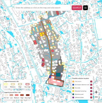
Mitigrate, an InsurTech SaaS startup, has rapidly advanced since securing funding from the European Space Agency (ESA). In the first month, the team engaged with 20 diverse insurance companies, gathering valuable feedback through Lloyd's of London's accelerator program. These interactions deepened the team’s understanding of use cases and product requirements in the insurance industry. Consequently, the team refined the product development strategy to align precisely with the needs of the target audience. Progressing to technical aspects, the team made significant strides in data collection and preprocessing. Utilizing high-resolution DEM (1m), a flood model is run, determining the location and depth of accumulated water for property risk assessment. Simultaneously, generation of an applicability map was explored, pinpointing optimal locations for preventive measures. The prototype displays bluespots, water flow paths, risk levels, and applicable solutions, showcasing Mitigrate's commitment to innovative and data-driven flood risk management.
