Objectives of the service
Rural Tourism 5.0 (RT5.0) is a next generation travel planning ‘eco-algorithm’, designed to improve the visitor experience, impact on the environment, and the economic output of rural tourist destinations.
The new technology embraces an “attract and disperse” agenda, with the aim of spreading demand across visitor attractions, accommodation, and food and beverage merchants without diminishing existing levels of business. Developed over 2 years, including a 6-month visitor engagement program during Spring and Summer 2024, RT5.0 encourages people to shift to public transport, creating significant environmental benefits for residents and visitors by reducing traffic noise and air pollution.
The project also focuses on understanding and mitigating the effects of ‘fly parking’ (parking in undesignated roadside and off-road areas, especially at popular holiday times) which causes further problems for communities, businesses, and visitors alike, by affecting access to towns, villages, and visitor attractions.
The potential financial return on investment could be significant. The UK government acknowledges that developing rural tourism and supporting services is key to long-term economic and social welfare. It’s estimated that the north and southwest of England account for 23% of the UK tourism economy, generating £21.7bn in 2018. To successfully boost growth and overcome tourists’ perceived dependency on travelling by car, which was compounded by the pandemic, there is a collective desire to create more engaging ways of enhancing visitors’ overall experience. Understanding the pressure on access points to areas of outstanding natural beauty and helping visitors to enjoy points of interest without creating pinch-points and bottlenecks is integral to the project.
Users and their needs
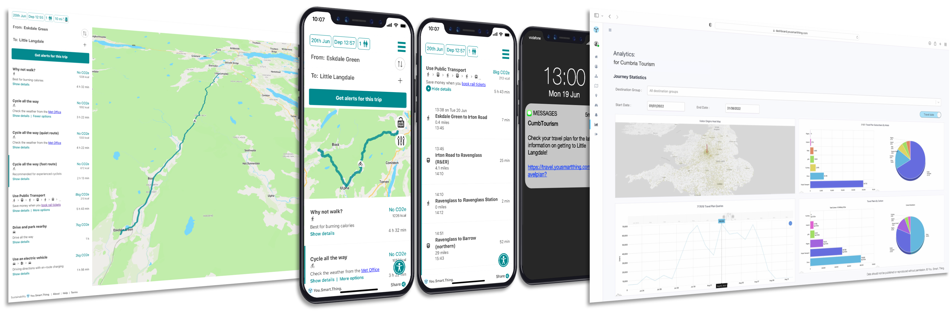
As part of the RT5.0 project a web-based travel assistant application has been commissioned for use by visitors to two of the UK’s leading tourist destinations, The Lake District and Cornwall. The travel assistant promotes recommended routes and low-carbon travel plans, including public transport itineraries that also incorporate cycling and walking.
Balancing Growth with Environmental Sustainability
Providing viable family friendly multimodal choices, and nudging tourist behaviours towards active travel to and from rural destinations, has the potential to dramatically reduce the sectors carbon footprint. Stakeholders believe the space enabled RT5.0 travel assistant service can help manage increasing demand, alongside maintaining the biodiversity and attractiveness of the natural environment. In this way, RT5.0 is expected to help balance environmental sustainability with economic growth, benefiting visitors, host communities, and the planet.
Service/ system concept
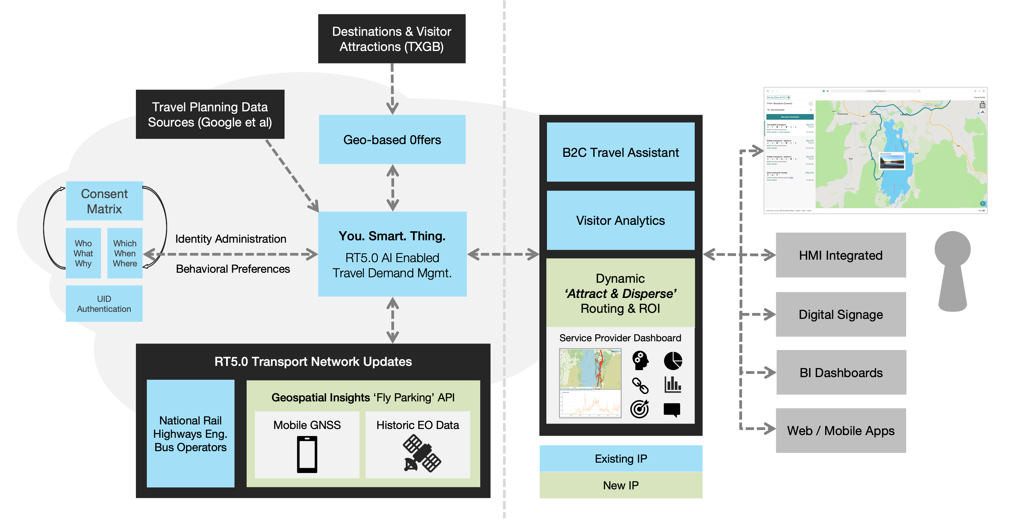
The service is easily embedded in websites and can be linked to from marketing communications and promotional collateral. Uniquely, it addresses the issue of fly parking using data from satellite imagery as part of a new eco-algorithm, designed to help reroute visitors around congested hotspots, and redistribute peak time demand by promoting viable alternatives to travelling by car.
The system architecture, outlined below, combines Low Earth Observation data with mobile GNSS data to create a predictive model, indicating likely times and dates, and to what extent, access roads may be nearing capacity. This indicator then feeds the eco-algorithm which in turn applies business rules to optimise the dispersal of visitors in the most sustainable and economically viable way.
Space Added Value
The use of space-based technologies including historic Low Earth Orbit (LEO) satellite images and data from newly sourced Synthetic Aperture Radar (SAR) images helps to continually enhance the RT5.0 enabled routing algorithm, offering visitors travel options that are optimised to help achieve regional environmental and economic objectives. This represents a step-change in the purpose and utility of travel planning services.
Optical satellite imagery is provided by a range of optical satellite options, including Airbus, Planet, Maxar and BlackSky, where possible and appropriate. Archive imagery will be employed to understand previous parking behaviours, and new acquisition implemented to monitor known problem locations.
Satellite imagery will be used in parallel mobile data during the project. Satellite imagery provides a complete picture of traffic and parked cars at a given moment in time. However, its frequency is limited, which leaves a gap in the overall picture. Mobile data does provide a continual stream of data however its availability is limited to ~10% of the total population, making it impossible to use in isolation to predict congestion. The project will use both data sources to create a continuous stream of data that will model the total volume of traffic and congestion at a given location.
Current Status
The project team has successfully finalised the detailed prototype designs for their upcoming Destination Management Organisation (DMO) administrative dashboard. This comprehensive dashboard encompasses the management of routing options and business rules, providing intricate analytics on travel behaviours crucial for supporting their Travel Demand Management (TDM) objectives.
Simultaneously, preparations for onsite acceptance testing are underway. Tourist partners are actively planning the deployment of their Travel Assistant configurations for public use. This deployment aims to facilitate baseline data collection in anticipation of the forthcoming beta testing phase.
Rural Tourism 5.0 is a modular component of travel demand management platform ‘You. Smart. Thing.’, developed with support from Geospatial Insight, Cumbria Tourism and Visit Cornwall. The project is co-funded by the European Space Agency under its Advanced Research in Telecommunications Systems 4.0 (ARTES 4.0) Business Applications – Space Solutions funding stream.
Prime Contractor(s)
Subcontractor(s)