
Objectives of the service
The project's objectives were the development, integration, validation and pre-operation of a Decision Support Service to monitor the integrity of oil & gas transmission pipelines.
By integrating space services and technologies (SatEO, SatNav, SatCom) with terrestrial systems, PIMSyS aims to (i) improve regularity and effectiveness of monitoring and inspection operations, (ii) increase safety and (iii) reduce operating cost for pipeline operators.
PIMSyS realises this by:
- Detecting Third Party Interferences (TPI), which mostly are threats related to excavation activities and building of settlements near the subsurface pipelines. These activities are recognized through change detection techniques using SatEO SAR (Synthetic Aperture Radar) data.
- Identifying ground elevation changes which are related to erosion, landslides and man-made activities (e.g. mine-shafts) and that can affect the pipelines integrity. Monitoring of ground elevation movements uses the SAR Permanent Scatterer Interferometry technique.
- Monitoring pipeline health status by measuring in-situ sensors installed along the pipeline infrastructure and by enabling field operators to register visual evidences of threats witnessed during their surveys (e.g. damage of the protective layer, holes, etc.). The exact location of the measurements and visual evidences collected are geo-tagged thanks to a mobile device. The mobile device transmits the information in real-time to the PIMSyS processing centre using a mobile satellite communication link.
- Guiding field operators, thanks to GNSS navigation, to the exact location where threats have been identified. The application is installed on the same mobile device as mentioned above and presents a map of the area of interest where all surroundings threats have been located.
Users and their needs
The users are operators of high-pressure gas transmission pipelines.
The major sources for failures of transmission pipelines are Third Party Interferences (TPI) and Ground Elevation Movements (GEM).
In a densely populated deltaic area like the Netherlands GEM monitoring and detection of some aspects of TPI (i.e. illegal excavation and illegal construction) are the most important needs. For South-Africa the most important needs are all aspects of TPI.
The major needs are :
- Need for regular monitoring: PIMSyS is making use of SAR satellite data, i.e. high reliable data source (independent of e.g. weather conditions).
- Scalability and performance: PIMSyS will use cloud services for notifications for Third Party Interferences (TPI) and Ground Elevation Movements (GEM).
- Full coverage of extensive pipeline systems with short revisit times, e.g. full coverage of Europe every 3 à 4 days.
- High performance database which allows interactive geographic visualisation of pipeline systems with the granularity of individual pipes (length ~12m).
- To ease interpretation PIMSyS provides the capability to correlate TPI and GEM threat notifications with 3rd party activities and CP anomalies.
- To support field inspectors, a mobile tablet computer provides location based information of TPI and GEM notifications, 3rd party activities, CP anomalies and pipeline system.
The users, for the demonstration projects are operators of high-pressure gas transmission pipelines in the Netherlands (Gasunie) and South-Africa (Sasol). For the commercial phase, the service will expand to operators of gas & oil transmission pipelines worldwide.
Service/ system concept
The diagram below gives an overview of the system:
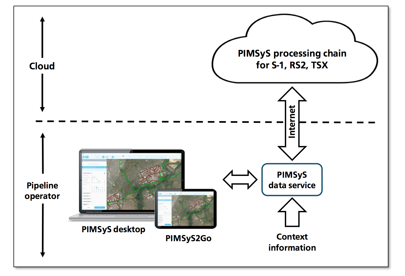
The Third Party Interference (TPI) and the Ground Elevation Movement (GEM) notification services are cloud services operated from the offices of S[&]T and Hansje Brinker BV. The PIMSyS system (database, client desktop and tablet computer) is at the location of clients.
Each time a new satellite image is received the system generates TPI and GEM notifications for the pipeline route. These notifications are stored in the PIMSyS database can be interpreted with the GIS based Analysis Module at the Client desktop.
The Analysis module reads all existing notifications and their status from the database. The Analysis module presents the notifications both as icons on a geographic map and as a list. The geographic map also presents the pipeline route and all available pipeline information. The notifications can be filtered with respect to date, type, etc. The user will classify notifications as: ignore, potential thread, etc. For the analysis of the notifications information is available about 3rd party activities and CP anomalies.
A mobile device (tablet computer) supports the following functions:
- Provide during field trips to service engineers and to other personnel information about the pipeline system and about all notifications in the PIMSyS database. Using the GNSS readings on the LBS the information will be presented relative to their current position on a geographical map.
Via the LBS also field observations (text & photo’s) are captured, geo tagged and sent to the PIMSyS database. For example, when the inspectors via the CP measurements localise damages in the coating of pipes, the GNSS readings of the LBS can be used to automatically generate a CP warning on the command of the inspector. The built-in camera of the tablet device can be used to further annotate the generated warning.
Space Added Value
PIMSyS is based on the integration of multiple space (SatEO, SatNav, SatCom) and terrestrial assets. Space assets are instrumental for the efficiency of the service:
- Satellite Earth Observation: Synthetic Aperture Radar (SAR) data and EO optical imagery are used to identify and locate possible threats against pipeline integrity and issue warnings to the pipeline operators. Change detection and Interferometry techniques are applied to the acquired SAR data in order to detect events such as presence of excavation vehicles, presence of buildings or man-made structures and ground level variations in the pipeline locations.
- Satellite Navigation: The use of satellite navigation is essential to guide pipeline inspectors to the exact location of where integrity warnings have been raised and to geo-tag threats detected and measurements made during field inspections (manually, vehicles, helicopters).
- Satellite Communications: mobile satcom data links provide reliable and global connectivity in order to relay measurements from in-situ sensors located along the pipeline infrastructure (including in isolated areas) as well as visual evidences identified by field operators and make them available in real-time to the PIMSyS processing centre.
Current Status
The project has ended successfully. Orbital Eye BV is further commercializing the product. A first contract with a five-years duration has been awarded by one of the major gas pipeline operators.
Currently, Orbital Eye BV is speaking with five other gas transportation companies for similar services.
OE is also continuously improving the system in order to better serve their customers. This development program will result in a product with enhanced functionality, interfacing possibilities to more asset management systems, integration with other PIMS functionality, and a better usability.
ADDITIONAL CONTRACTOR PROJECT MANAGER
Jan Ridder
Orbital Eye
Kepplerstraat 1
2201 BB Noordwijk
The Netherlands
E-mail: ridder@orbitaleye.nl
Phone: +31 15 262 98 89