Objectives of the service
Regarding the maritime business sector, the Contractor has dealt with different opportunities and activities that could greatly benefit from evolutionary scenarios characterized by the presence of innovative telecommunication solutions like VDES.
In particular, the “Dematerialisation” and “Towage” scenarios are considered for the present study, as they furthermore match the guidelines for MSP.
The former is aimed to share common information among vessels navigating the same geographical area, usually delivered on paper publications, such as the pilot book and the related file summaries and notice to mariners, other than nautical charts and weather forecast updates. The service could introduce a real time update of all the navigation information updates and enable smart user generated content review and publishing.
The latter is aimed to support companies in providing towage services, by automatically exchanging towage information and events (start/end of services, routes and anchorages, crew, weather nowcasting for towage and mooring operations, etc.) with the HQ and automatically produce towage reports; the service includes tug and towed vessel tracking during the services and trouble management procedures.
Users and their needs
VDES provides a robust and global data exchange in maritime VHF band, supporting all services which require ship-to-ship, shore-to-ship and ship-to-shore communications. Therefore, the targeted user communities include:
- Maritime and Port authorities
- Sea ports and marinas
- Ship owners and operators
- Fishing operators
- Recreational boating
whose main needs can be summarised as follows:
- safety of life at sea
- enhanced maritime security
- maritime communications
- safety and efficiency of navigation
- cost effective solutions
- marine environment protection.
The two selected VDES-based services concern maritime authorities and ship owners, involving all the above-mentioned needs, with more prominence for communication and navigation needs.
More in depth, information regarding safety of navigation and environment protection, including Maritime Safety Information (IMO SOLAS V) navigational warnings, meteorological services and warnings, hydrographic services and danger messages could be managed through VDES. In addition ability to send information to a predefined area, such as in particular weather information updates expected along a planned route and chart updates related to the voyage, could be enabled.
VDES could also provide the capability to exchange information related to ship arriving at a port, including time of arrival and requests for port service such as stores, fuel, pilots, tugs and other aspects for the transit.
To effectively meet these needs, the following main operational challenges have been identified:
- a tight configuration has to be accurately selected to satisfy all requirements for the selected services and achieve target performances.
- uncertainty on VDES specification and presence (esp. satellite component) is a critical point: an impact analysis on both selected services has to be conducted, looking for alternative solutions
- delivery model definition is also a crucial issue: SaaS (Software as a Service) vs traditional, related to number and similarities of potential customers, is a strategy to be analysed together with the business plan.
MARVELOWS exploitation strategy is based on a four-step approach, characterized by an increasing geographic scope for targeted users: Italy for step 1, UK, Scandinavian countries, Netherlands, France, Spain, Germany, Greece and Cyprus for step 2, other European countries and Israel for step 3, worldwide level for step 4.
Service/ system concept
The figure below describes the MARVELOWS Dematerialisation service architecture.
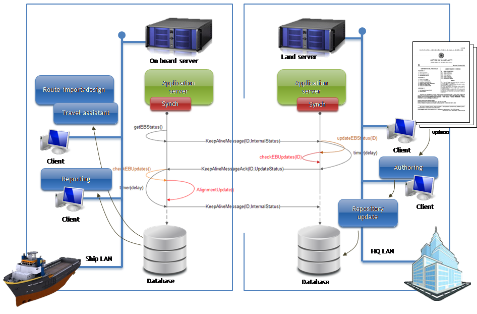
It is based on two subsystems, i.e. land and on-board server. In detail, looking at the overall service operation:
- The two sub-systems are kept synchronized through a protocol based on events and notifications, optimized for use with limited bandwidth, but also with support of wireless terrestrial channels;
- The timestamp associated to a group of contents synchronized between on-board and land together with the expiring date enables the users to have immediate evidence of the validity of contents used, evaluating each time the opportunity to perform updates (outside the automatic preset schedule);
- The on-board server operates independently from the land server, referring to the latter for updates and off-line consultation of the contents.
The figure below depicts the MARVELOWS Towage service architecture.
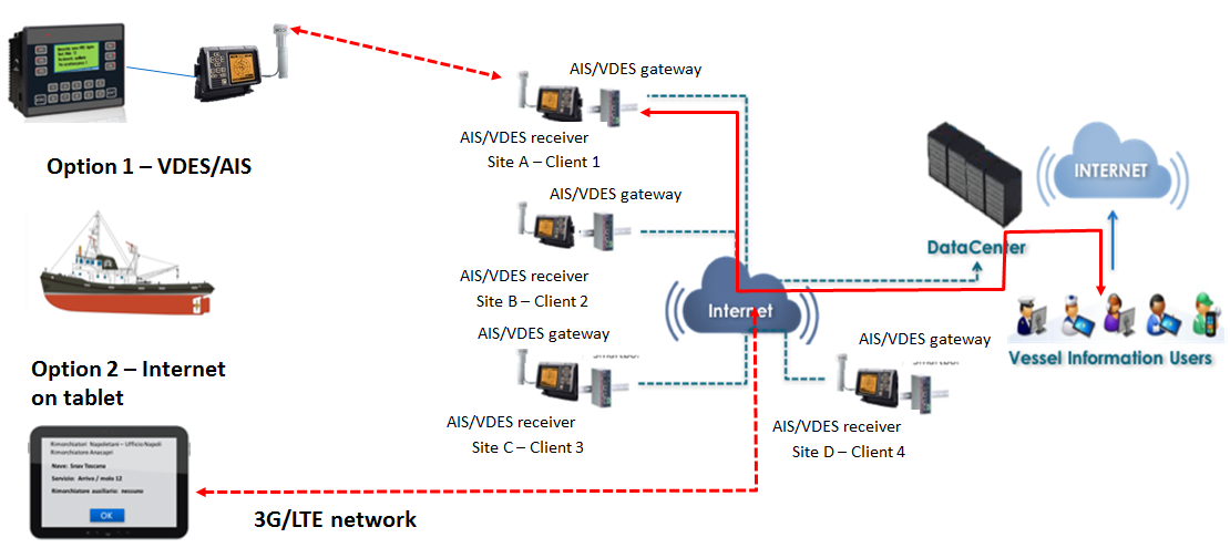
It envisages several channels for both ship-to-shore and shore-to-ship communications: VDES, for deep sea towage, and VDES terrestrial, 3G and LTE, for near shore navigation.
The proposed service allows the automatic exchange of towage information and events with headquarters and automatically produces towage reports. It brings several benefits to end-users enabling full process automation and allows the creation of archives for all the activities carried out by towage companies.
Space Added Value
As reported in the “White Paper on Integrating Maritime Surveillance: the Implementation of the Common Information Sharing Environment” (EC Nov-2012), in the EU and EEA 400 public authorities throughout seven relevant sectors collect information at sea from different types of sensors to build up their “awareness picture”. This “awareness picture” could be significantly improved if information were shared appropriately between these authorities. The lack of information exchange across sectors and borders lead to a series of inefficiencies constituting the practical and the political context of today: the “maritime awareness picture” that remains incomplete. So, the integration of satcom and navigation space assets can contribute to the enhancement of the maritime applications in several ways. For example, in general:
- To contribute to the generation of an enhanced Common Operating Picture (eCOP) through integration of different geo-localized information s collected and transferred by terrestrial and satellite systems and communication links.
- To support Maritime Surveillance & Control operations by enhancing vessel monitoring thanks to an accurate and reliable geo-fencing and empowering ship-to-shore/shore-to-ship real-time data exchange exploiting satcom services and location-based information.
With specific reference to the two services analysed in MARVELOWS:
a) Towage Service: GNSS/AIS position of vessels and tugs are used to support the management of daily operations of, for example, one or more tugs driving a vessel to the assigned berth; satcom are used to support the communication between local crew and headquarter in the management of contingencies in out-of-coverage areas along the coast and/or far from the harbour, where no terrestrial operator guarantee connectivity services.
b) Dematerialisation Service: GNSS/AIS position of vessels are used to provide location-based content to registered vessels, both in push and pull mode through the ‘better communication channel’ among the available one. Contents are various and depend on the specific subscription, however two main classes of content have been identified: ‘large-size’ content (e.g. ENC-Electronic Nautical Chart, DP-Digital Publications, Cumulative NTM-Notice To Mariner and so on) and ‘small-size’ content (e.g. ENC/DP updates, temporary and preliminary info, Local Notice to Mariner). Large-size contents are transmitted via “broadband” communication channels (terrestrial and satellite along the coasts and satellite-only in deep sea); small-size contents are transmitted via narrowband channels (terrestrial and satellite along the coasts and satellite-only in deep sea).
Current Status
The feasibility study started on 1st March 2017.
The following activities were carried out:
- Stakeholder Analysis: definition of user/stakeholder database with related contact information, preparation of interview material, preliminary desk-analysis for user requirements definition;
- VDES technology analysis: state of the art of the VDES technology and roadmap, assessment of the expected VDES system and components performances, outcomes of IMO and IALA workgroups about the technologies enabled by VDES and regulations, technical, regulatory and commercial barriers for development and market entry of the considered VDES services;
- Viability analysis: preliminary analysis for both proposed services in terms of market (size and segmentation, drivers and trends), definition of first provisioning chains and pricing strategies, focused mainly on commercial risks;
- Roadmap and Recommendation: exploitation roadmap and main recommendation for the MARVELOWS project beyond the feasibility study;
- User and service requirements review for the two identified services (Dematerialisation and Towage).
The project is concluded.
Prime Contractor(s)

Subcontractor(s)