
Objectives of the service
The main objective of DROMAS Agricultural Crop Monitoring services is to enable operational full country monitoring of agricultural vegetation to respond to the needs of the Czech State Agricultural Intervention Fund (SAIF). The focus is to support the Area Monitoring System (AMS) operation in Czechia, namely the aid application control processes and management of Land Parcel Identification System (LPIS).
Another services have been implemented and demonstrated within the project extension to support the ongoing transformation of agricultural sector towards smart farming and application of precision agriculture practices. DROMAS Farming Management Services are based on an innovative methodology to monitor agricultural crops at parcel level to support farm decision making. They deliver field-level historical time-series analysis of crop spatial variability and provide current crop growth monitoring to enhance the farming management practice.
Users and their needs
DROMAS Agricultural Crop Monitoring services were implemented and demonstrated in close collaboration with the State Agricultural Intervention Fund (SAIF) that acts as Czech national paying agency. The availability and performances of Copernicus EO data opened the way to revisit completely the EO use in the context of the CAP. The concept of “Checks by Monitoring” is to substitute existing sample control approach (5% on-the-spot-checks) by a new Area Monitoring System (AMS) that shall enable controls of all applications or claims. The main drivers for introducing the AMS are the reduction of the burden of controls, limiting the scope of field visits and using warning alerts in combination with an option to correct the aid application in order to prevent non-compliances.
Czech Republic
Service/ system concept
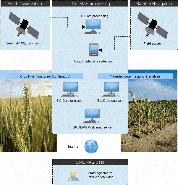
The DROMAS services consist of two group of services aimed at country based and farm level crop monitoring.
DROMAS Agricultural Crop Monitoring Services
Two categories of services have been implemented during the demonstration project based on two different application domains:
A) DROMAS Control services
The main aim of these services is to support the CAP subsidy controls and the implementation of national Area Monitoring System. They include:
-
Monitoring of crops on arable land
The service aims at crop classification and farming practices monitoring. It supports the monitoring of compliance with the principles of environmentally sound farm management.
-
Monitoring of grassland management
The service supports the grassland eligibility monitoring with the aim to identify the absence of any grassland maintenance practices (mowing, grazing) applied on the grassland parcel.
-
Monitoring of permanent crops
The service aims at detection of parcels that are not well maintained and actively used for agricultural production.
B) DROMAS LPIS services
The main aim of these services is to improve the quality of the LPIS and the LPIS update process. They include:
-
Improving the quality of the LPIS
Identification of “suspected” LPIS parcels (in term of incorrect parcel area, parcel boundary, crop category, presence of uncultivated land and non-eligible features) that are not properly represented in the LPIS.
-
Support to LPIS update process
Verification of LPIS update requests to assess the correctness of reported situation by comparison with recent Sentinel imagery. The service provides quick “on-line” check of each submitted LPIS update request to identify cases that need specific attention and additional effort to process the request.
DROMAS Farming Management Service
Two categories of services are included:
A) Historical time-series analysis of crop spatial variability
It provides the assessment of parcel heterogeneity to support farmer’s decision about the potential benefit of introduction of variable management for individual crops grown on each parcel. Historical time-series of Landsat and Sentinel-2 imagery are processed to assess stable long-term aspects of crop management on the parcel.
B) Analysis of crop biophysical parameters for current crop growing season
It provides set of products represented by crop biophysical parameters that describe specific aspects of crop canopy status during the entire crop growing season. The farmer can use different products (chlorophyll content, water content, leaf area index) to plan and apply different type of variable parcel management (fertilization, pest protection, irrigation, sowing).
Space Added Value
Earth Observation and Satellite Navigation represent two space assets that enable implementation of the service compliant with identified user requirements.
Earth Observation is the only technology that can provide feasible solution for operational full country crop monitoring in needed spatial and temporal resolution.
Satellite Navigation is the technology providing the solution for operational targeted in-situ data collection focused on support of satellite image data analysis.
Current Status
After the completion of the feasibility study in 2015, the DROMAS Demonstration Project started in January 2016. All the demonstration activities have been carried out during 2018. The demonstration phase run smoothly with very active participation of the user in each individual demonstration scenario. All the provided services have been validated and user’s assessment was rather positive. The successful conclusion of demonstration activities has been confirmed by series of commercial contracts awarded by the Czech State Agricultural Intervention Fund in 2019 and 2020.
Due to the complete revisit of the use of EO data in the context of the European Common Agricultural Policy the potential of DROMAS type of services has significantly increased. The new approach based on the Area Monitoring System brings much wider scope within which the Sentinel imagery may be analyzed to support the subsidy controls. Number of additional applications and services have been identified and discussed with SAIF. Based on that additional services have been implemented and demonstrated within the project extension period (2020 – 2022).