Objectives of the service
Climate change impacts coastal areas through the rise of sea level amplifying the impact of extreme natural events such as hurricanes and coastal storms. Sea level rise induces shoreline erosion, coastal flooding, water salinization and more, threatening the livelihoods, population growth, urbanization, and natural ecosystems. It drives thus significant economic losses and affects the built-up areas behind the coastline.
CORISCLIM tool helps to envision climate-related coastal risk wherever and act ahead of time to mitigate their impacts, to update plans, to launch additional in-depth studies, to strengthen local capacities and build coastal resilience, and more.
Users and their needs
CORISCLIM tool is fitted to the use of:
-
Coastal authorities anticipating future risks to protect the coastal communities, lives and property.
-
Coastal engineering firms & consultancies and companies managing the coastal zones and their risks.
-
Development banks or private investors funding climate resilience actions.
-
Climate Insurance firms evaluating future impacts on your clients’ assets.
-
Environmental associations and organizations (NGOs) supporting climate change awareness and actions.
It answers their needs to:
-
Identify coastal areas potentially exposed to future coastal flood hazards due to mean sea level rise and extreme events with the most accurate information available everywhere in the world.
-
Prioritize and decide where to deploy your actions (insurance solutions, investments, financial support, lobby, awareness & stakeholder engagement, in-depth studies, …)
-
Communicate about future coastal risks with an appealing and easy-access tool to improve customer experience and support awareness and commercial promotional activities.
With CORISCLIM, you will
-
Assess the future risks at medium to large scale to prioritise and focus your actions.
-
Communicate / share this risk-knowledge to support internal priority decisions.
-
Have an handsome representation to raise awareness of sea level rise impact and engage stakeholders.
-
Edit terms of references for in-depth impact studies or engineering expertise
-
Improve collaboration with practitioners and other stakeholders through an effective and impactful work supported by this tool.
Service/ system concept
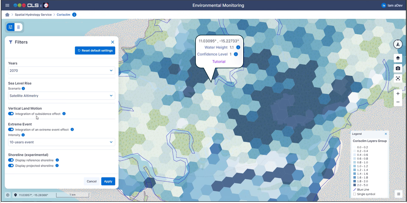
The system and service architecture is schematised below.
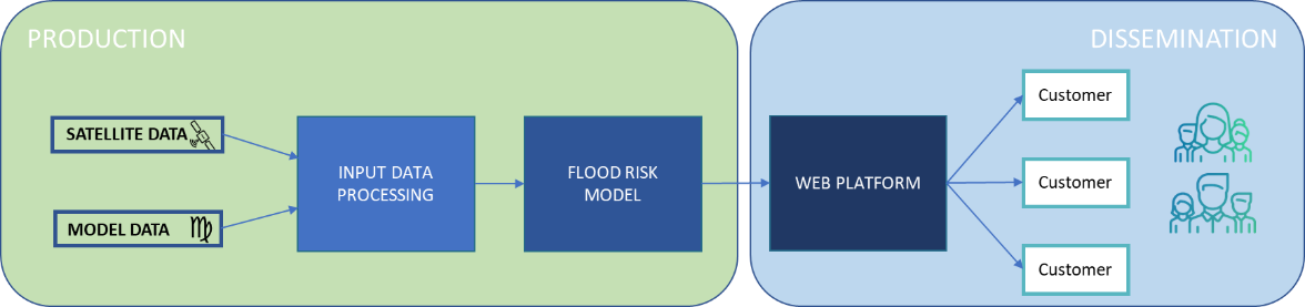
The online visualisation platform provides worldwide maps of future coastal hazards until horizon 2100 from the latest advanced research and satellite observations and allows to play along multiple scenarios.
The access is provided along 3 service levels :
-
Standard level - Free
-
Prognostics for 2030, 2050 and 2100, with or without 10years extreme events
-
Visualization only, zoom limit to 1 km
-
No subsidence, erosion impacts
-
-
Advance level
-
Prognostics of Sea Level Rise per decade, 2030, 2040 2050, 2060, 2070, 2080, 2090 and 2100,
-
Resolution enhanced to 300m.
-
Visualization and access to products, with multi return periods of extreme events, (5, 10, 50 or 100 years), waves runup effect, subsidence, erosion impacts.
-
-
Custom level
-
Same functionalities as advance level plus visualisation of external vulnerability maps considering local assets coming from customers or external databases.
-
Space Added Value
CORISCLIM service is possible thanks to 4 satellite systems monitoring the pulse of our planet:
-
Radar altimetry
to monitor the ocean dynamics at world scale (sea level trends, waves, storm surges, tides)
-
Optical imagery
to monitor coastal erosion at world scale and capture land cover/land use
-
LIDAR
whose data are used for the Digital Elevation Model
-
Synthetic Aperture Radar
to monitor land subsidence over Europe
Current Status
The project has started in February 2023. The CORISCLIM service will be freely available for demonstration from May 2024 until October 2024.
If you are interested to be a pilot user, please contact us.
Prime Contractor(s)
Subcontractor(s)