Objectives of the service
Farm managers need efficient and objective means to monitor their crops, to evaluate the outcome of field operations and plan how much and where to apply fertiliser and crop protection agents. For monitoring crop status, farmers can use high resolution images at specific times during the growing season. Bioscope will set up a reliably service of vegetation monitoring based on the integrated use of satellites and Remotely Piloted Aircraft Systems (RPAS).
Users and their needs
The primary market for BIOSCOPE is potato cultivation in Europe. The service targets two segments of the potation cultivation: farm managers and farm advisors. This includes farmers, agronomists, extension services, laboratories and contractors. Remote sensing based information products can support agricultural users in decision making in many different processes. Agricultural users have clear demands that can be translated in clear requirements and service specifications. The most pressing need in this is the guarantee to deliver information products in predefined time windows. Furthermore, the data must be directly usable, not more than one week old and cost-effective.
BIOSCOPE will target the Netherlands and Belgium first, before expanding to the rest of Europe in a second stage.
Service/ system concept
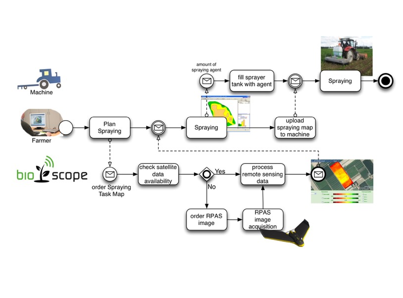
The objective of this project is to start up a Fast, Flexible, Timely and Reliable service that deliver relevant information with an advice to the farmer. For this purpose, BIOSCOPE chooses an appropriate mix of satellite and drone image acquisitions, to best meet the customer's requirements (e.g. timing, and resolution) based on satellite availability and weather condition. Thereby the service will foster a wider use of satellite imagery with a key role of data from the Copernicus Sentinel-2 mission.
The BIOSCOPE service provides the complete chain from the satellite to the machinery that performs the task in the field. The remote sensing information is integrated in the standard agricultural processes as well as the standard agricultural software, guaranteeing ease of use for the farmer. Using standard data protocols to deliver the data from the BIOSCOPE service to the farm management systems will guarantee a significant level of acceptance among the farming community.
Space Added Value
BIOSCOPE makes use of two space assets, Earth Observation and Satellite Navigation:
- Earth Observation is used for the service itself, in particular the very high resolution sensors in the visible and infrared parts of the spectrum;
- Satellite Navigation (GNSS) and EGNOS is used for auto guidance of the drone and registration of the position where images are taken. This information is also of great importance for geo-referencing and further processing of the data.;
Satellite Navigation is also used to deploy the services outputs (e.g. task maps) in the field.
Current Status
Following the completion of the feasibility study, the BIOSCOPE Demonstration Project started early 2016. Building on the analysis of interviews with farmers and other stakeholders to frame better the actual user demand for BIOSCOPE, the Baseline Design Review has been completed in April 2016. Currently the team is design the service and its different components.
Prime Contractor(s)
Subcontractor(s)